Nonnweiler geodata
Nonnweiler (Saarland) is a seat of a fourth-order administrative division; located in Germany in Europe/Berlin (GMT+2) time zone. With population of 9,417 people, there are 1716 cities with bigger population in this country. Compared to other cities in Germany, 73.6% of cities are located further ↑North; 93.7% of cities are located further →East and 74.9% of cities have lower elevation than Nonnweiler. Note1


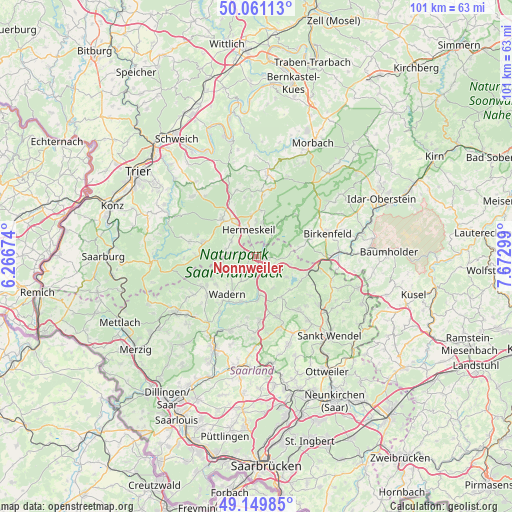
Nonnweiler GPS coordinates[2]
49° 36' 27.432" North, 6° 58' 11.496" East
| Map corner | latitude | longitude |
|---|---|---|
| Upper-left | 50.06113°, | 6.26674° |
| Center: | 49.60762°, | 6.96986° |
| Lower-right: | 49.14985°, | 7.67299° |
| Map W x H: | 101.3×101.3 km | = 62.9×62.9mi |
| max Lat: | 55.01917° ⇑73.6% North |
| Nonnweiler: | 49.60762° |
| min Lat: | ⇓26.4% South 47.40724° |
| min Long | Nonnweiler | max Long |
| 5.92978° | 6.96986° | 14.98853° |
| W 6.3%⇐ | ⇒93.7% E |
Elevation
Elevation of Nonnweiler is 397 m = 1302 ft, and this is 147.9 m = 485 ft above average elevation for this country.
| Max E: |
1256 m = 4121 ft | 25.1% |
| Nonnweiler | 397 m 1302 ft | |
| Avg. | 249.1 m = 817 ft | |
Min E: |
-5 m = -16 ft | 74.9% |
See also: Germany elevation on elevation.city.
Geographical zone
Nonnweiler is located in North temperate zone (between Tropic of Cancer and the Arctic Circle). Distance of this North polar circle is 1885.3 km =1171.5 mi to North.| Distance of | km | miles | from Nonnweiler |
|---|---|---|---|
| North Pole | 4491.2 | 2790.7 | to North |
| Arctic Circle | 1885.3 | 1171.5 | to North |
| Tropic Cancer | 2909.9 | 1808.1 | to South |
| Equator | 5515.9 | 3427.4 | to South |


Nearby cities:
15 places around Nonnweiler: (largest is in red/bold)
• Abentheuer
10.5 km =6.5 mi,  63°
63°
• Achtelsbach
8.9 km =5.5 mi,  77°
77°
• Brücken
11 km =6.8 mi,  74°
74°
• Damflos
6.6 km =4.1 mi,  8°
8°
• Grimburg
6.3 km =3.9 mi,  279°
279°
• Gusenburg
5.8 km =3.6 mi,  299°
299°
• Hermeskeil
5.6 km =3.5 mi,  340°
340°
• Hinzert-Pölert
11.4 km =7.1 mi,  333°
333°
• Kell
10.9 km =6.8 mi,  285°
285°
• Kell am See
11 km =6.8 mi, 284°
• Meckenbach
9.4 km =5.8 mi, 83°
• Neuhütten
5.1 km =3.2 mi,  39°
39°
• Reinsfeld
10.5 km =6.5 mi,  323°
323°
• Wadern
9.5 km =5.9 mi,  218°
218°
• Züsch
5.2 km =3.2 mi,  24°
24°
Sources, notices
• [Note1] Compared only with cities in Germany existing in our database
• [Src1] Map data: © OpenStreetMap contributors (CC-BY-SA)
• [Src2] Other city data from geonames.org with taken over terms of usage.
• [Src3] Geographical zone / Annual Mean Temperature by Robert A. Rohde @ Wikipedia
