Tholey geodata
Tholey (Saarland) is a seat of a fourth-order administrative division; located in Germany in Europe/Berlin (GMT+2) time zone. With population of 13,157 people, there are 1218 cities with bigger population in this country. Compared to other cities in Germany, 76% of cities are located further ↑North; 92.9% of cities are located further →East and 73.9% of cities have lower elevation than Tholey. Note1


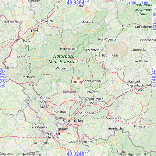
Tholey GPS coordinates[2]
49° 29' 1.464" North, 7° 2' 12.876" East
| Map corner | latitude | longitude |
|---|---|---|
| Upper-left | 49.93841°, | 6.33379° |
| Center: | 49.48374°, | 7.03691° |
| Lower-right: | 49.02481°, | 7.74004° |
| Map W x H: | 101.6×101.6 km | = 63.1×63.1mi |
| max Lat: | 55.01917° ⇑76% North |
| Tholey: | 49.48374° |
| min Lat: | ⇓24% South 47.40724° |
| min Long | Tholey | max Long |
| 5.92978° | 7.03691° | 14.98853° |
| W 7.1%⇐ | ⇒92.9% E |
Elevation
Elevation of Tholey is 389 m = 1276 ft, and this is 139.9 m = 459 ft above average elevation for this country.
| Max E: |
1256 m = 4121 ft | 26.1% |
| Tholey | 389 m 1276 ft | |
| Avg. | 249.1 m = 817 ft | |
Min E: |
-5 m = -16 ft | 73.9% |
See also: Germany elevation on elevation.city.
Geographical zone
Tholey is located in North temperate zone (between Tropic of Cancer and the Arctic Circle). Distance of this North polar circle is 1899.1 km =1180 mi to North.| Distance of | km | miles | from Tholey |
|---|---|---|---|
| North Pole | 4505 | 2799.3 | to North |
| Arctic Circle | 1899.1 | 1180 | to North |
| Tropic Cancer | 2896.2 | 1799.6 | to South |
| Equator | 5502.1 | 3418.8 | to South |


Nearby cities:
15 places around Tholey: (largest is in red/bold)
• Eppelborn
10.6 km =6.6 mi,  208°
208°
• Illingen
12.3 km =7.6 mi,  176°
176°
• Lebach
12.2 km =7.6 mi,  228°
228°
• Mainzweiler
9.4 km =5.8 mi,  141°
141°
• Marpingen
3.8 km =2.4 mi,  156°
156°
• Merchweiler
14.9 km =9.3 mi, 176°
• Namborn
8.6 km =5.3 mi,  60°
60°
• Nohfelden
13.8 km =8.6 mi,  33°
33°
• Nonnweiler
14.6 km =9.1 mi,  340°
340°
• Oberthal
4.7 km =2.9 mi,  46°
46°
• Ottweiler
13 km =8.1 mi,  134°
134°
• Sankt Wendel
9.7 km =6 mi,  101°
101°
• Schiffweiler
14.8 km =9.2 mi,  151°
151°
• Schmelz
14.6 km =9.1 mi,  247°
247°
• Wadern
12.5 km =7.8 mi,  300°
300°
Sources, notices
• [Note1] Compared only with cities in Germany existing in our database
• [Src1] Map data: © OpenStreetMap contributors (CC-BY-SA)
• [Src2] Other city data from geonames.org with taken over terms of usage.
• [Src3] Geographical zone / Annual Mean Temperature by Robert A. Rohde @ Wikipedia
