Pilsting geodata
Pilsting (Bavaria) is a populated place; located in Germany in Europe/Berlin (GMT+2) time zone. With population of 6,194 people, there are 2403 cities with bigger population in this country. Compared to other cities in Germany, 86.4% of cities are located further ↑North; 89.4% of cities are located further ←West and 68.1% of cities have lower elevation than Pilsting. Note1
Administrative division(s):
- Level 1: Bavaria
- Level 2: Lower Bavaria
- Level 3: Landkreis Dingolfing-Landau
- Level 4: Pilsting, Markt


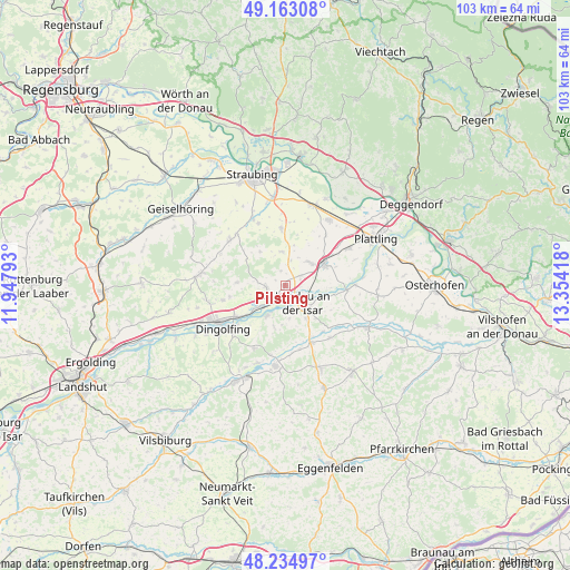
Pilsting GPS coordinates[2]
48° 42' 4.176" North, 12° 39' 3.78" East
| Map corner | latitude | longitude |
|---|---|---|
| Upper-left | 49.16308°, | 11.94793° |
| Center: | 48.70116°, | 12.65105° |
| Lower-right: | 48.23497°, | 13.35418° |
| Map W x H: | 103.2×103.2 km | = 64.1×64.1mi |
| max Lat: | 55.01917° ⇑86.4% North |
| Pilsting: | 48.70116° |
| min Lat: | ⇓13.6% South 47.40724° |
| min Long | Pilsting | max Long |
| 5.92978° | 12.65105° | 14.98853° |
| W 89.4%⇐ | ⇒10.6% E |
Elevation
Elevation of Pilsting is 343 m = 1125 ft, and this is 93.9 m = 308 ft above average elevation for this country.
| Max E: |
1256 m = 4121 ft | 31.9% |
| Pilsting | 343 m 1125 ft | |
| Avg. | 249.1 m = 817 ft | |
Min E: |
-5 m = -16 ft | 68.1% |
See also: Germany elevation on elevation.city.
Geographical zone
Pilsting is located in North temperate zone (between Tropic of Cancer and the Arctic Circle). Distance of this North polar circle is 1986.1 km =1234.1 mi to North.| Distance of | km | miles | from Pilsting |
|---|---|---|---|
| North Pole | 4592 | 2853.3 | to North |
| Arctic Circle | 1986.1 | 1234.1 | to North |
| Tropic Cancer | 2809.1 | 1745.5 | to South |
| Equator | 5415.1 | 3364.8 | to South |


Nearby cities:
15 places around Pilsting: (largest is in red/bold)
• Dingolfing
13.3 km =8.3 mi,  240°
240°
• Gottfrieding
11.1 km =6.9 mi,  230°
230°
• Landau an der Isar
4.4 km =2.7 mi,  135°
135°
• Leiblfing
12.8 km =8 mi,  310°
310°
• Mamming
6.3 km =3.9 mi,  209°
209°
• Mengkofen
15.6 km =9.7 mi,  277°
277°
• Moosthenning
11.6 km =7.2 mi,  256°
256°
• Oberpöring
12.8 km =8 mi,  89°
89°
• Oberschneiding
10.5 km =6.5 mi,  356°
356°
• Otzing
13.4 km =8.3 mi,  59°
59°
• Reisbach
14.7 km =9.1 mi,  186°
186°
• Salching
13.5 km =8.4 mi,  334°
334°
• Simbach
16.3 km =10.1 mi,  156°
156°
• Straßkirchen
15.3 km =9.5 mi,  19°
19°
• Wallersdorf
8.2 km =5.1 mi, 60°
Sources, notices
• [Note1] Compared only with cities in Germany existing in our database
• [Src1] Map data: © OpenStreetMap contributors (CC-BY-SA)
• [Src2] Other city data from geonames.org with taken over terms of usage.
• [Src3] Geographical zone / Annual Mean Temperature by Robert A. Rohde @ Wikipedia
