Inchenhofen geodata
Inchenhofen (Bavaria) is a populated place; located in Germany in Europe/Berlin (GMT+2) time zone. With population of 2,390 people, there are 4567 cities with bigger population in this country. Compared to other cities in Germany, 89% of cities are located further ↑North; 68.6% of cities are located further ←West and 83.9% of cities have lower elevation than Inchenhofen. Note1
Administrative division(s):
- Level 1: Bavaria
- Level 2: Swabia
- Level 3: Landkreis Aichach-Friedberg
- Level 4: Inchenhofen, Markt


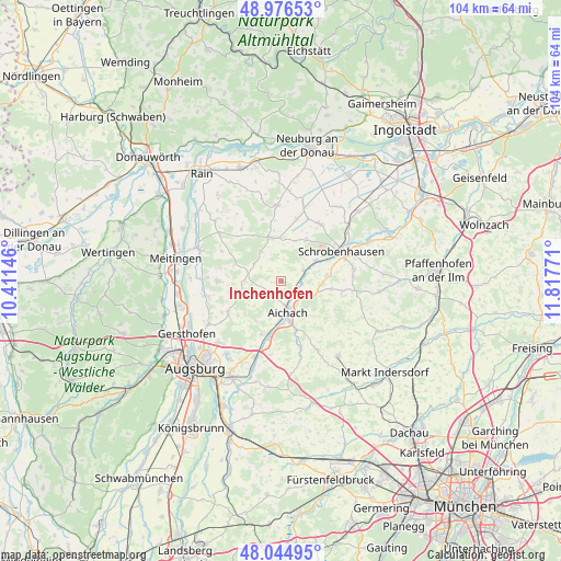
Inchenhofen GPS coordinates[2]
48° 30' 46.368" North, 11° 6' 52.488" East
| Map corner | latitude | longitude |
|---|---|---|
| Upper-left | 48.97653°, | 10.41146° |
| Center: | 48.51288°, | 11.11458° |
| Lower-right: | 48.04495°, | 11.81771° |
| Map W x H: | 103.6×103.6 km | = 64.4×64.4mi |
| max Lat: | 55.01917° ⇑89% North |
| Inchenhofen: | 48.51288° |
| min Lat: | ⇓11% South 47.40724° |
| min Long | Inchenhofen | max Long |
| 5.92978° | 11.11458° | 14.98853° |
| W 68.6%⇐ | ⇒31.4% E |
Elevation
Elevation of Inchenhofen is 461 m = 1512 ft, and this is 211.9 m = 695 ft above average elevation for this country.
| Max E: |
1256 m = 4121 ft | 16.1% |
| Inchenhofen | 461 m 1512 ft | |
| Avg. | 249.1 m = 817 ft | |
Min E: |
-5 m = -16 ft | 83.9% |
See also: Germany elevation on elevation.city.
Geographical zone
Inchenhofen is located in North temperate zone (between Tropic of Cancer and the Arctic Circle). Distance of this North polar circle is 2007 km =1247.1 mi to North.| Distance of | km | miles | from Inchenhofen |
|---|---|---|---|
| North Pole | 4612.9 | 2866.3 | to North |
| Arctic Circle | 2007 | 1247.1 | to North |
| Tropic Cancer | 2788.2 | 1732.5 | to South |
| Equator | 5394.1 | 3351.7 | to South |


Nearby cities:
15 places around Inchenhofen: (largest is in red/bold)
• Affing
11 km =6.8 mi,  242°
242°
• Aichach
6.3 km =3.9 mi,  166°
166°
• Aindling
11.9 km =7.4 mi,  270°
270°
• Ehekirchen
13.4 km =8.3 mi,  355°
355°
• Gachenbach
8.9 km =5.5 mi,  99°
99°
• Hollenbach
4.8 km =3 mi,  227°
227°
• Kühbach
5.9 km =3.7 mi,  114°
114°
• Langenmosen
12.7 km =7.9 mi,  35°
35°
• Obergriesbach
10.6 km =6.6 mi,  198°
198°
• Petersdorf
6 km =3.7 mi, 274°
• Pöttmes
8.1 km =5 mi,  345°
345°
• Ried
11.5 km =7.1 mi, 110°
• Schiltberg
11.3 km =7 mi,  119°
119°
• Schrobenhausen
12 km =7.5 mi,  63°
63°
• Sielenbach
13.1 km =8.1 mi,  162°
162°
Sources, notices
• [Note1] Compared only with cities in Germany existing in our database
• [Src1] Map data: © OpenStreetMap contributors (CC-BY-SA)
• [Src2] Other city data from geonames.org with taken over terms of usage.
• [Src3] Geographical zone / Annual Mean Temperature by Robert A. Rohde @ Wikipedia
