Petersdorf geodata
Petersdorf (Bavaria) is a seat of a fourth-order administrative division; located in Germany in Europe/Berlin (GMT+2) time zone. With population of 1,719 people, there are 5477 cities with bigger population in this country. Compared to other cities in Germany, 89% of cities are located further ↑North; 67.4% of cities are located further ←West and 86.9% of cities have lower elevation than Petersdorf. Note1
Administrative division(s):
- Level 1: Bavaria
- Level 2: Swabia
- Level 3: Landkreis Aichach-Friedberg
- Level 4: Petersdorf


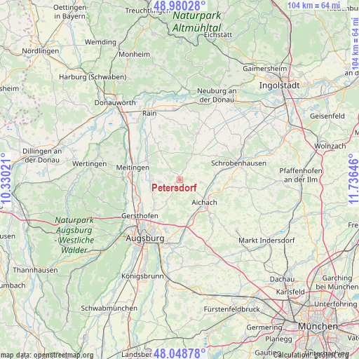
Petersdorf GPS coordinates[2]
48° 31' 0.012" North, 11° 1' 59.988" East
| Map corner | latitude | longitude |
|---|---|---|
| Upper-left | 48.98028°, | 10.33021° |
| Center: | 48.51667°, | 11.03333° |
| Lower-right: | 48.04878°, | 11.73646° |
| Map W x H: | 103.6×103.6 km | = 64.4×64.4mi |
| max Lat: | 55.01917° ⇑89% North |
| Petersdorf: | 48.51667° |
| min Lat: | ⇓11% South 47.40724° |
| min Long | Petersdorf | max Long |
| 5.92978° | 11.03333° | 14.98853° |
| W 67.4%⇐ | ⇒32.6% E |
Elevation
Elevation of Petersdorf is 485 m = 1591 ft, and this is 235.9 m = 774 ft above average elevation for this country.
| Max E: |
1256 m = 4121 ft | 13.1% |
| Petersdorf | 485 m 1591 ft | |
| Avg. | 249.1 m = 817 ft | |
Min E: |
-5 m = -16 ft | 86.9% |
See also: Germany elevation on elevation.city.
Geographical zone
Petersdorf is located in North temperate zone (between Tropic of Cancer and the Arctic Circle). Distance of this North polar circle is 2006.6 km =1246.8 mi to North.| Distance of | km | miles | from Petersdorf |
|---|---|---|---|
| North Pole | 4612.5 | 2866.1 | to North |
| Arctic Circle | 2006.6 | 1246.8 | to North |
| Tropic Cancer | 2788.6 | 1732.8 | to South |
| Equator | 5394.5 | 3352 | to South |


Nearby cities:
15 places around Petersdorf: (largest is in red/bold)
• Affing
6.7 km =4.2 mi,  213°
213°
• Aichach
9.9 km =6.2 mi,  131°
131°
• Aindling
5.9 km =3.7 mi,  266°
266°
• Ehekirchen
13.9 km =8.6 mi,  20°
20°
• Hollenbach
4.4 km =2.7 mi,  146°
146°
• Holzheim
12.2 km =7.6 mi,  329°
329°
• Inchenhofen
6 km =3.7 mi,  94°
94°
• Kühbach
11.7 km =7.3 mi,  104°
104°
• Langweid
13.6 km =8.5 mi,  257°
257°
• Meitingen
13.8 km =8.6 mi,  283°
283°
• Obergriesbach
10.7 km =6.6 mi,  166°
166°
• Pöttmes
8.5 km =5.3 mi,  28°
28°
• Rehling
8.2 km =5.1 mi,  243°
243°
• Thierhaupten
10.7 km =6.6 mi,  300°
300°
• Todtenweis
7.7 km =4.8 mi, 270°
Sources, notices
• [Note1] Compared only with cities in Germany existing in our database
• [Src1] Map data: © OpenStreetMap contributors (CC-BY-SA)
• [Src2] Other city data from geonames.org with taken over terms of usage.
• [Src3] Geographical zone / Annual Mean Temperature by Robert A. Rohde @ Wikipedia
