Wadern geodata
Wadern (Saarland) is a populated place; located in Germany in Europe/Berlin (GMT+2) time zone. With population of 17,282 people, there are 922 cities with bigger population in this country. Compared to other cities in Germany, 74.9% of cities are located further ↑North; 94.6% of cities are located further →East and 61.1% of cities have lower elevation than Wadern. Note1


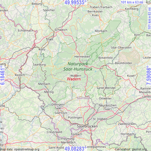
Wadern GPS coordinates[2]
49° 32' 28.392" North, 6° 53' 15.864" East
| Map corner | latitude | longitude |
|---|---|---|
| Upper-left | 49.99535°, | 6.18461° |
| Center: | 49.54122°, | 6.88774° |
| Lower-right: | 49.08283°, | 7.59086° |
| Map W x H: | 101.5×101.5 km | = 63.1×63.1mi |
| max Lat: | 55.01917° ⇑74.9% North |
| Wadern: | 49.54122° |
| min Lat: | ⇓25.1% South 47.40724° |
| min Long | Wadern | max Long |
| 5.92978° | 6.88774° | 14.98853° |
| W 5.4%⇐ | ⇒94.6% E |
Elevation
Elevation of Wadern is 296 m = 971 ft, and this is 46.9 m = 154 ft above average elevation for this country.
| Max E: |
1256 m = 4121 ft | 38.9% |
| Wadern | 296 m 971 ft | |
| Avg. | 249.1 m = 817 ft | |
Min E: |
-5 m = -16 ft | 61.1% |
See also: Germany elevation on elevation.city.
Geographical zone
Wadern is located in North temperate zone (between Tropic of Cancer and the Arctic Circle). Distance of this North polar circle is 1892.7 km =1176.1 mi to North.| Distance of | km | miles | from Wadern |
|---|---|---|---|
| North Pole | 4498.6 | 2795.3 | to North |
| Arctic Circle | 1892.7 | 1176.1 | to North |
| Tropic Cancer | 2902.5 | 1803.5 | to South |
| Equator | 5508.5 | 3422.8 | to South |


Nearby cities:
15 places around Wadern: (largest is in red/bold)
• Grimburg
8.4 km =5.2 mi,  357°
357°
• Gusenburg
10.3 km =6.4 mi,  4°
4°
• Hermeskeil
13.3 km =8.3 mi,  17°
17°
• Kell
11.3 km =7 mi,  336°
336°
• Kell am See
11.3 km =7 mi, 335°
• Losheim
10.8 km =6.7 mi,  251°
251°
• Mandern
10.9 km =6.8 mi,  306°
306°
• Neuhütten
14.5 km =9 mi,  39°
39°
• Nonnweiler
9.5 km =5.9 mi, 38°
• Oberthal
14.5 km =9 mi,  102°
102°
• Schillingen
12.7 km =7.9 mi,  323°
323°
• Schmelz
12.3 km =7.6 mi,  192°
192°
• Tholey
12.5 km =7.8 mi,  120°
120°
• Waldweiler
10.5 km =6.5 mi, 322°
• Weiskirchen
5.2 km =3.2 mi,  280°
280°
Sources, notices
• [Note1] Compared only with cities in Germany existing in our database
• [Src1] Map data: © OpenStreetMap contributors (CC-BY-SA)
• [Src2] Other city data from geonames.org with taken over terms of usage.
• [Src3] Geographical zone / Annual Mean Temperature by Robert A. Rohde @ Wikipedia
