Bronkow geodata
Bronkow (Brandenburg) is a seat of a fourth-order administrative division; located in Germany in Europe/Berlin (GMT+2) time zone. With population of 691 people, there are 8356 cities with bigger population in this country. Compared to other cities in Germany, 68.5% of cities are located further ↓South; 97.6% of cities are located further ←West and 63.6% of cities have higher elevation than Bronkow. Note1
Administrative division(s):
- Level 1: Brandenburg
- Level 3: Landkreis Oberspreewald-Lausitz
- Level 4: Bronkow


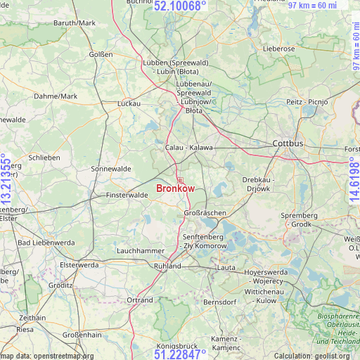
Bronkow GPS coordinates[2]
51° 40' 0.012" North, 13° 55' 0.012" East
| Map corner | latitude | longitude |
|---|---|---|
| Upper-left | 52.10068°, | 13.21355° |
| Center: | 51.66667°, | 13.91667° |
| Lower-right: | 51.22847°, | 14.6198° |
| Map W x H: | 97×97 km | = 60.3×60.3mi |
| max Lat: | 55.01917° ⇑31.5% North |
| Bronkow: | 51.66667° |
| min Lat: | ⇓68.5% South 47.40724° |
| min Long | Bronkow | max Long |
| 5.92978° | 13.91667° | 14.98853° |
| W 97.6%⇐ | ⇒2.4% E |
Elevation
Elevation of Bronkow is 128 m = 420 ft, and this is 121.1 m = 397 ft below average elevation for this country.
| Max E: |
1256 m = 4121 ft | 63.6% |
| Avg. | 249.1 m = 817 ft | |
| Bronkow | 128 m = 420 ft | |
Min E: |
-5 m = -16 ft | 36.4% |
See also: Germany elevation on elevation.city.
Geographical zone
Bronkow is located in North temperate zone (between Tropic of Cancer and the Arctic Circle). Distance of this North polar circle is 1656.4 km =1029.2 mi to North.| Distance of | km | miles | from Bronkow |
|---|---|---|---|
| North Pole | 4262.3 | 2648.5 | to North |
| Arctic Circle | 1656.4 | 1029.2 | to North |
| Tropic Cancer | 3138.9 | 1950.4 | to South |
| Equator | 5744.8 | 3569.7 | to South |


Nearby cities:
15 places around Bronkow: (largest is in red/bold)
• Altdöbern
8.3 km =5.2 mi,  102°
102°
• Calau
9 km =5.6 mi,  16°
16°
• Crinitz
12.7 km =7.9 mi,  305°
305°
• Drebkau
21.2 km =13.2 mi,  93°
93°
• Finsterwalde
14.9 km =9.3 mi,  255°
255°
• Großräschen
10.9 km =6.8 mi,  143°
143°
• Lichterfeld
12.3 km =7.6 mi,  231°
231°
• Neupetershain
18.3 km =11.4 mi,  110°
110°
• Sallgast
9.9 km =6.2 mi,  208°
208°
• Schipkau
16.6 km =10.3 mi,  184°
184°
• Schwarzheide
21.5 km =13.4 mi,  191°
191°
• Senftenberg
16.8 km =10.4 mi,  159°
159°
• Sonnewalde
18.8 km =11.7 mi,  278°
278°
• Vetschau
17.4 km =10.8 mi,  40°
40°
• Welzow
19.8 km =12.3 mi,  117°
117°
Sources, notices
• [Note1] Compared only with cities in Germany existing in our database
• [Src1] Map data: © OpenStreetMap contributors (CC-BY-SA)
• [Src2] Other city data from geonames.org with taken over terms of usage.
• [Src3] Geographical zone / Annual Mean Temperature by Robert A. Rohde @ Wikipedia
