Obernzell geodata
Obernzell (Bavaria) is a populated place; located in Germany in Europe/Berlin (GMT+2) time zone. With population of 3,843 people, there are 3383 cities with bigger population in this country. Compared to other cities in Germany, 88.4% of cities are located further ↑North; 96.5% of cities are located further ←West and 60.9% of cities have lower elevation than Obernzell. Note1
Administrative division(s):
- Level 1: Bavaria
- Level 2: Lower Bavaria
- Level 3: Landkreis Passau
- Level 4: Obernzell, Markt


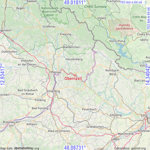
Obernzell GPS coordinates[2]
48° 33' 17.46" North, 13° 38' 14.244" East
| Map corner | latitude | longitude |
|---|---|---|
| Upper-left | 49.01811°, | 12.93417° |
| Center: | 48.55485°, | 13.63729° |
| Lower-right: | 48.08731°, | 14.34042° |
| Map W x H: | 103.5×103.5 km | = 64.3×64.3mi |
| max Lat: | 55.01917° ⇑88.4% North |
| Obernzell: | 48.55485° |
| min Lat: | ⇓11.6% South 47.40724° |
| min Long | Obernzell | max Long |
| 5.92978° | 13.63729° | 14.98853° |
| W 96.5%⇐ | ⇒3.5% E |
Elevation
Elevation of Obernzell is 295 m = 968 ft, and this is 45.9 m = 151 ft above average elevation for this country.
| Max E: |
1256 m = 4121 ft | 39.1% |
| Obernzell | 295 m 968 ft | |
| Avg. | 249.1 m = 817 ft | |
Min E: |
-5 m = -16 ft | 60.9% |
See also: Germany elevation on elevation.city.
Geographical zone
Obernzell is located in North temperate zone (between Tropic of Cancer and the Arctic Circle). Distance of this North polar circle is 2002.4 km =1244.2 mi to North.| Distance of | km | miles | from Obernzell |
|---|---|---|---|
| North Pole | 4608.3 | 2863.5 | to North |
| Arctic Circle | 2002.4 | 1244.2 | to North |
| Tropic Cancer | 2792.9 | 1735.4 | to South |
| Equator | 5398.8 | 3354.7 | to South |


Nearby cities:
15 places around Obernzell: (largest is in red/bold)
• Büchlberg
15.5 km =9.6 mi,  326°
326°
• Hauzenberg
10.6 km =6.6 mi,  355°
355°
• Hutthurm
17.9 km =11.1 mi,  317°
317°
• Neuburg
15 km =9.3 mi,  249°
249°
• Neuhaus am Inn
19.1 km =11.9 mi,  236°
236°
• Passau
15.2 km =9.4 mi,  274°
274°
• Ruderting
19.4 km =12.1 mi,  303°
303°
• Salzweg
13.2 km =8.2 mi, 301°
• Sonnen
15.4 km =9.6 mi,  22°
22°
• Thyrnau
10.3 km =6.4 mi,  311°
311°
• Tiefenbach
19.1 km =11.9 mi,  293°
293°
• Untergriesbach
3.1 km =1.9 mi,  45°
45°
• Waldkirchen
20 km =12.4 mi,  352°
352°
• Wegscheid
12.2 km =7.6 mi,  64°
64°
• Witzmannsberg
12.9 km =8 mi, 305°
Sources, notices
• [Note1] Compared only with cities in Germany existing in our database
• [Src1] Map data: © OpenStreetMap contributors (CC-BY-SA)
• [Src2] Other city data from geonames.org with taken over terms of usage.
• [Src3] Geographical zone / Annual Mean Temperature by Robert A. Rohde @ Wikipedia
