Nettersheim geodata
Nettersheim (North Rhine-Westphalia) is a seat of a fourth-order administrative division; located in Germany in Europe/Berlin (GMT+2) time zone. With population of 7,901 people, there are 1969 cities with bigger population in this country. Compared to other cities in Germany, 53% of cities are located further ↑North; 96.9% of cities are located further →East and 82.8% of cities have lower elevation than Nettersheim. Note1
Administrative division(s):
- Level 1: North Rhine-Westphalia
- Level 2: Regierungsbezirk Köln
- Level 3: Kreis Euskirchen
- Level 4: Nettersheim


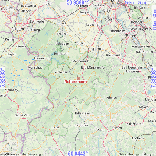
Nettersheim GPS coordinates[2]
50° 29' 37.392" North, 6° 37' 44.256" East
| Map corner | latitude | longitude |
|---|---|---|
| Upper-left | 50.93891°, | 5.92583° |
| Center: | 50.49372°, | 6.62896° |
| Lower-right: | 50.0443°, | 7.33208° |
| Map W x H: | 99.5×99.5 km | = 61.8×61.8mi |
| max Lat: | 55.01917° ⇑53% North |
| Nettersheim: | 50.49372° |
| min Lat: | ⇓47% South 47.40724° |
| min Long | Nettersheim | max Long |
| 5.92978° | 6.62896° | 14.98853° |
| W 3.1%⇐ | ⇒96.9% E |
Elevation
Elevation of Nettersheim is 452 m = 1483 ft, and this is 202.9 m = 666 ft above average elevation for this country.
| Max E: |
1256 m = 4121 ft | 17.2% |
| Nettersheim | 452 m 1483 ft | |
| Avg. | 249.1 m = 817 ft | |
Min E: |
-5 m = -16 ft | 82.8% |
See also: Germany elevation on elevation.city.
Geographical zone
Nettersheim is located in North temperate zone (between Tropic of Cancer and the Arctic Circle). Distance of this North polar circle is 1786.8 km =1110.3 mi to North.| Distance of | km | miles | from Nettersheim |
|---|---|---|---|
| North Pole | 4392.7 | 2729.5 | to North |
| Arctic Circle | 1786.8 | 1110.3 | to North |
| Tropic Cancer | 3008.5 | 1869.4 | to South |
| Equator | 5614.4 | 3488.6 | to South |


Nearby cities:
15 places around Nettersheim: (largest is in red/bold)
• Aremberg
14.8 km =9.2 mi,  125°
125°
• Bad Münstereifel
11.9 km =7.4 mi,  53°
53°
• Blankenheim
6.9 km =4.3 mi,  167°
167°
• Dahlem
13.3 km =8.3 mi,  205°
205°
• Eichenbach
14.9 km =9.3 mi,  116°
116°
• Esch
14.2 km =8.8 mi,  183°
183°
• Feusdorf
16 km =9.9 mi, 183°
• Hellenthal
13.9 km =8.6 mi,  265°
265°
• Hümmel
11.3 km =7 mi,  105°
105°
• Jünkerath
17 km =10.6 mi,  191°
191°
• Kall
7.1 km =4.4 mi,  319°
319°
• Mechernich
11.2 km =7 mi,  8°
8°
• Ohlenhard
10.9 km =6.8 mi, 116°
• Schleiden
11.4 km =7.1 mi,  290°
290°
• Wershofen
14.1 km =8.8 mi, 112°
Sources, notices
• [Note1] Compared only with cities in Germany existing in our database
• [Src1] Map data: © OpenStreetMap contributors (CC-BY-SA)
• [Src2] Other city data from geonames.org with taken over terms of usage.
• [Src3] Geographical zone / Annual Mean Temperature by Robert A. Rohde @ Wikipedia
