Kall geodata
Kall (North Rhine-Westphalia) is a seat of a fourth-order administrative division; located in Germany in Europe/Berlin (GMT+2) time zone. With population of 11,903 people, there are 1377 cities with bigger population in this country. Compared to other cities in Germany, 51.9% of cities are located further ↑North; 97.4% of cities are located further →East and 73.2% of cities have lower elevation than Kall. Note1
Administrative division(s):
- Level 1: North Rhine-Westphalia
- Level 2: Regierungsbezirk Köln
- Level 3: Kreis Euskirchen
- Level 4: Kall


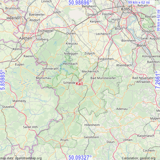
Kall GPS coordinates[2]
50° 32' 32.028" North, 6° 33' 46.692" East
| Map corner | latitude | longitude |
|---|---|---|
| Upper-left | 50.98696°, | 5.85985° |
| Center: | 50.54223°, | 6.56297° |
| Lower-right: | 50.09327°, | 7.2661° |
| Map W x H: | 99.4×99.4 km | = 61.8×61.8mi |
| max Lat: | 55.01917° ⇑51.9% North |
| Kall: | 50.54223° |
| min Lat: | ⇓48.1% South 47.40724° |
| min Long | Kall | max Long |
| 5.92978° | 6.56297° | 14.98853° |
| W 2.6%⇐ | ⇒97.4% E |
Elevation
Elevation of Kall is 384 m = 1260 ft, and this is 134.9 m = 443 ft above average elevation for this country.
| Max E: |
1256 m = 4121 ft | 26.8% |
| Kall | 384 m 1260 ft | |
| Avg. | 249.1 m = 817 ft | |
Min E: |
-5 m = -16 ft | 73.2% |
See also: Germany elevation on elevation.city.
Geographical zone
Kall is located in North temperate zone (between Tropic of Cancer and the Arctic Circle). Distance of this North polar circle is 1781.4 km =1106.9 mi to North.| Distance of | km | miles | from Kall |
|---|---|---|---|
| North Pole | 4387.3 | 2726.1 | to North |
| Arctic Circle | 1781.4 | 1106.9 | to North |
| Tropic Cancer | 3013.9 | 1872.8 | to South |
| Equator | 5619.8 | 3492 | to South |


Nearby cities:
15 places around Kall: (largest is in red/bold)
• Bad Münstereifel
14.3 km =8.9 mi,  83°
83°
• Blankenheim
13.6 km =8.5 mi,  153°
153°
• Dahlem
17.4 km =10.8 mi,  183°
183°
• Einruhr
13.6 km =8.5 mi,  289°
289°
• Heimbach
12.4 km =7.7 mi,  327°
327°
• Hellenthal
11.3 km =7 mi,  234°
234°
• Hümmel
17.7 km =11 mi,  118°
118°
• Mechernich
8.5 km =5.3 mi,  48°
48°
• Nettersheim
7.1 km =4.4 mi,  139°
139°
• Nideggen
17.6 km =10.9 mi,  341°
341°
• Ohlenhard
17.7 km =11 mi,  125°
125°
• Rurberg
15.1 km =9.4 mi,  301°
301°
• Schleiden
6.3 km =3.9 mi,  256°
256°
• Simmerath
19.7 km =12.2 mi, 289°
• Zulpich
18.1 km =11.2 mi,  20°
20°
Sources, notices
• [Note1] Compared only with cities in Germany existing in our database
• [Src1] Map data: © OpenStreetMap contributors (CC-BY-SA)
• [Src2] Other city data from geonames.org with taken over terms of usage.
• [Src3] Geographical zone / Annual Mean Temperature by Robert A. Rohde @ Wikipedia
