Hellenthal geodata
Hellenthal (North Rhine-Westphalia) is a seat of a fourth-order administrative division; located in Germany in Europe/Berlin (GMT+2) time zone. With population of 8,582 people, there are 1864 cities with bigger population in this country. Compared to other cities in Germany, 53.2% of cities are located further ↑North; 98.3% of cities are located further →East and 77.6% of cities have lower elevation than Hellenthal. Note1
Administrative division(s):
- Level 1: North Rhine-Westphalia
- Level 2: Regierungsbezirk Köln
- Level 3: Kreis Euskirchen
- Level 4: Hellenthal


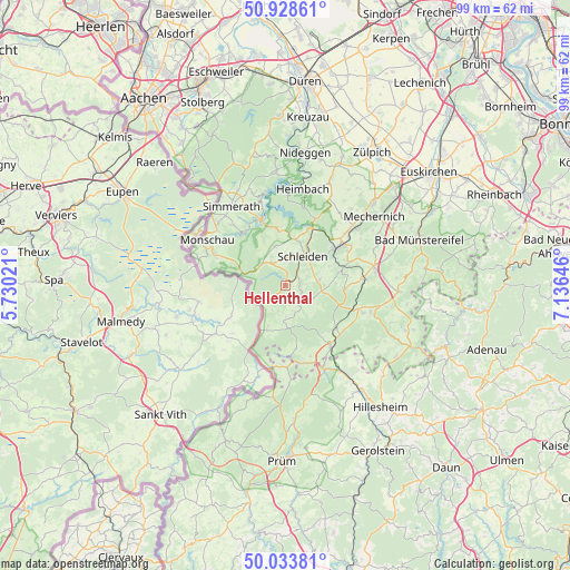
Hellenthal GPS coordinates[2]
50° 28' 59.988" North, 6° 25' 59.988" East
| Map corner | latitude | longitude |
|---|---|---|
| Upper-left | 50.92861°, | 5.73021° |
| Center: | 50.48333°, | 6.43333° |
| Lower-right: | 50.03381°, | 7.13646° |
| Map W x H: | 99.5×99.5 km | = 61.8×61.8mi |
| max Lat: | 55.01917° ⇑53.2% North |
| Hellenthal: | 50.48333° |
| min Lat: | ⇓46.8% South 47.40724° |
| min Long | Hellenthal | max Long |
| 5.92978° | 6.43333° | 14.98853° |
| W 1.7%⇐ | ⇒98.3% E |
Elevation
Elevation of Hellenthal is 416 m = 1365 ft, and this is 166.9 m = 548 ft above average elevation for this country.
| Max E: |
1256 m = 4121 ft | 22.4% |
| Hellenthal | 416 m 1365 ft | |
| Avg. | 249.1 m = 817 ft | |
Min E: |
-5 m = -16 ft | 77.6% |
See also: Germany elevation on elevation.city.
Geographical zone
Hellenthal is located in North temperate zone (between Tropic of Cancer and the Arctic Circle). Distance of this North polar circle is 1788 km =1111 mi to North.| Distance of | km | miles | from Hellenthal |
|---|---|---|---|
| North Pole | 4393.8 | 2730.2 | to North |
| Arctic Circle | 1788 | 1111 | to North |
| Tropic Cancer | 3007.3 | 1868.6 | to South |
| Equator | 5613.2 | 3487.9 | to South |


Nearby cities:
15 places around Hellenthal: (largest is in red/bold)
• Blankenheim
16.3 km =10.1 mi,  109°
109°
• Dahlem
13.5 km =8.4 mi,  143°
143°
• Einruhr
11.7 km =7.3 mi,  341°
341°
• Hallschlag
14.3 km =8.9 mi,  178°
178°
• Heimbach
17.3 km =10.7 mi,  8°
8°
• Kall
11.3 km =7 mi,  54°
54°
• Kerschenbach
15.6 km =9.7 mi,  162°
162°
• Monschau
15.8 km =9.8 mi,  300°
300°
• Nettersheim
13.9 km =8.6 mi,  85°
85°
• Ormont
17.5 km =10.9 mi, 177°
• Rurberg
15 km =9.3 mi,  345°
345°
• Scheid
13.8 km =8.6 mi, 183°
• Schleiden
5.9 km =3.7 mi,  31°
31°
• Simmerath
16 km =9.9 mi,  324°
324°
• Stadtkyll
16.4 km =10.2 mi,  154°
154°
Sources, notices
• [Note1] Compared only with cities in Germany existing in our database
• [Src1] Map data: © OpenStreetMap contributors (CC-BY-SA)
• [Src2] Other city data from geonames.org with taken over terms of usage.
• [Src3] Geographical zone / Annual Mean Temperature by Robert A. Rohde @ Wikipedia
