Schleiden geodata
Schleiden (North Rhine-Westphalia) is a populated place; located in Germany in Europe/Berlin (GMT+2) time zone. With population of 14,160 people, there are 1124 cities with bigger population in this country. Compared to other cities in Germany, 52.2% of cities are located further ↑North; 98% of cities are located further →East and 71.1% of cities have lower elevation than Schleiden. Note1
Administrative division(s):
- Level 1: North Rhine-Westphalia
- Level 2: Regierungsbezirk Köln
- Level 3: Kreis Euskirchen
- Level 4: Schleiden


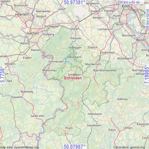
Schleiden GPS coordinates[2]
50° 31' 44.256" North, 6° 28' 36.912" East
| Map corner | latitude | longitude |
|---|---|---|
| Upper-left | 50.97381°, | 5.7738° |
| Center: | 50.52896°, | 6.47692° |
| Lower-right: | 50.07987°, | 7.18005° |
| Map W x H: | 99.4×99.4 km | = 61.8×61.8mi |
| max Lat: | 55.01917° ⇑52.2% North |
| Schleiden: | 50.52896° |
| min Lat: | ⇓47.8% South 47.40724° |
| min Long | Schleiden | max Long |
| 5.92978° | 6.47692° | 14.98853° |
| W 2%⇐ | ⇒98% E |
Elevation
Elevation of Schleiden is 367 m = 1204 ft, and this is 117.9 m = 387 ft above average elevation for this country.
| Max E: |
1256 m = 4121 ft | 28.9% |
| Schleiden | 367 m 1204 ft | |
| Avg. | 249.1 m = 817 ft | |
Min E: |
-5 m = -16 ft | 71.1% |
See also: Germany elevation on elevation.city.
Geographical zone
Schleiden is located in North temperate zone (between Tropic of Cancer and the Arctic Circle). Distance of this North polar circle is 1782.9 km =1107.8 mi to North.| Distance of | km | miles | from Schleiden |
|---|---|---|---|
| North Pole | 4388.8 | 2727.1 | to North |
| Arctic Circle | 1782.9 | 1107.8 | to North |
| Tropic Cancer | 3012.4 | 1871.8 | to South |
| Equator | 5618.3 | 3491 | to South |


Nearby cities:
15 places around Schleiden: (largest is in red/bold)
• Blankenheim
16.2 km =10.1 mi,  130°
130°
• Dahlem
16.7 km =10.4 mi,  162°
162°
• Einruhr
9.1 km =5.7 mi,  311°
311°
• Hallschlag
19.6 km =12.2 mi,  188°
188°
• Heimbach
12 km =7.5 mi,  357°
357°
• Hellenthal
5.9 km =3.7 mi,  211°
211°
• Kall
6.3 km =3.9 mi,  76°
76°
• Kerschenbach
20 km =12.4 mi,  175°
175°
• Mechernich
14.3 km =8.9 mi,  60°
60°
• Monschau
17 km =10.6 mi,  279°
279°
• Nettersheim
11.4 km =7.1 mi,  110°
110°
• Nideggen
18.2 km =11.3 mi,  1°
1°
• Rurberg
11.6 km =7.2 mi,  324°
324°
• Scheid
19.3 km =12 mi, 191°
• Simmerath
14.8 km =9.2 mi,  302°
302°
Sources, notices
• [Note1] Compared only with cities in Germany existing in our database
• [Src1] Map data: © OpenStreetMap contributors (CC-BY-SA)
• [Src2] Other city data from geonames.org with taken over terms of usage.
• [Src3] Geographical zone / Annual Mean Temperature by Robert A. Rohde @ Wikipedia
