Königsbronn geodata
Königsbronn (Baden-Württemberg) is a seat of a fourth-order administrative division; located in Germany in Europe/Berlin (GMT+2) time zone. With population of 7,420 people, there are 2089 cities with bigger population in this country. Compared to other cities in Germany, 86% of cities are located further ↑North; 51.8% of cities are located further ←West and 88.9% of cities have lower elevation than Königsbronn. Note1
Administrative division(s):
- Level 1: Baden-Württemberg
- Level 2: Regierungsbezirk Stuttgart
- Level 3: Landkreis Heidenheim
- Level 4: Königsbronn


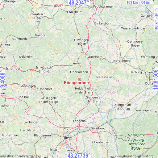
Königsbronn GPS coordinates[2]
48° 44' 35.412" North, 10° 6' 42.948" East
| Map corner | latitude | longitude |
|---|---|---|
| Upper-left | 49.2047°, | 9.4088° |
| Center: | 48.74317°, | 10.11193° |
| Lower-right: | 48.27736°, | 10.81506° |
| Map W x H: | 103.1×103.1 km | = 64.1×64.1mi |
| max Lat: | 55.01917° ⇑86% North |
| Königsbronn: | 48.74317° |
| min Lat: | ⇓14% South 47.40724° |
| min Long | Königsbronn | max Long |
| 5.92978° | 10.11193° | 14.98853° |
| W 51.8%⇐ | ⇒48.2% E |
Elevation
Elevation of Königsbronn is 503 m = 1650 ft, and this is 253.9 m = 833 ft above average elevation for this country.
| Max E: |
1256 m = 4121 ft | 11.1% |
| Königsbronn | 503 m 1650 ft | |
| Avg. | 249.1 m = 817 ft | |
Min E: |
-5 m = -16 ft | 88.9% |
See also: Germany elevation on elevation.city.
Geographical zone
Königsbronn is located in North temperate zone (between Tropic of Cancer and the Arctic Circle). Distance of this North polar circle is 1981.4 km =1231.2 mi to North.| Distance of | km | miles | from Königsbronn |
|---|---|---|---|
| North Pole | 4587.3 | 2850.4 | to North |
| Arctic Circle | 1981.4 | 1231.2 | to North |
| Tropic Cancer | 2813.8 | 1748.4 | to South |
| Equator | 5419.7 | 3367.6 | to South |


Nearby cities:
15 places around Königsbronn: (largest is in red/bold)
• Aalen
10.6 km =6.6 mi,  352°
352°
• Bartholomä
9.2 km =5.7 mi,  277°
277°
• Bolheim
12.7 km =7.9 mi,  167°
167°
• Böbingen an der Rems
16.3 km =10.1 mi,  301°
301°
• Böhmenkirch
14.7 km =9.1 mi,  243°
243°
• Essingen
9.5 km =5.9 mi,  319°
319°
• Gerstetten
15 km =9.3 mi,  206°
206°
• Heidenheim an der Brenz
7.8 km =4.8 mi,  158°
158°
• Herbrechtingen
14.3 km =8.9 mi, 160°
• Heubach
14.2 km =8.8 mi,  292°
292°
• Mögglingen
14.1 km =8.8 mi,  309°
309°
• Nattheim
10.7 km =6.6 mi,  116°
116°
• Neresheim
16.1 km =10 mi,  85°
85°
• Oberkochen
4.5 km =2.8 mi, 353°
• Steinheim am Albuch
6.8 km =4.2 mi, 211°
In other languages:
- In France: Abbaye de Königsbronn
- In German: Königsbronn, Kloster Königsbronn
- In Russian: Кёнигсброн
- In Chinese: 柯尼希斯布龙
Sources, notices
• [Note1] Compared only with cities in Germany existing in our database
• [Src1] Map data: © OpenStreetMap contributors (CC-BY-SA)
• [Src2] Other city data from geonames.org with taken over terms of usage.
• [Src3] Geographical zone / Annual Mean Temperature by Robert A. Rohde @ Wikipedia
