Nandlstadt geodata
Nandlstadt (Bavaria) is a populated place; located in Germany in Europe/Berlin (GMT+2) time zone. With population of 5,044 people, there are 2808 cities with bigger population in this country. Compared to other cities in Germany, 88.7% of cities are located further ↑North; 78.9% of cities are located further ←West and 85.2% of cities have lower elevation than Nandlstadt. Note1
Administrative division(s):
- Level 1: Bavaria
- Level 2: Upper Bavaria
- Level 3: Landkreis Freising
- Level 4: Nandlstadt, Markt


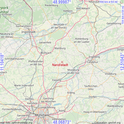
Nandlstadt GPS coordinates[2]
48° 32' 11.184" North, 11° 48' 26.28" East
| Map corner | latitude | longitude |
|---|---|---|
| Upper-left | 48.99987°, | 11.10418° |
| Center: | 48.53644°, | 11.8073° |
| Lower-right: | 48.06873°, | 12.51043° |
| Map W x H: | 103.5×103.5 km | = 64.3×64.3mi |
| max Lat: | 55.01917° ⇑88.7% North |
| Nandlstadt: | 48.53644° |
| min Lat: | ⇓11.3% South 47.40724° |
| min Long | Nandlstadt | max Long |
| 5.92978° | 11.8073° | 14.98853° |
| W 78.9%⇐ | ⇒21.1% E |
Elevation
Elevation of Nandlstadt is 471 m = 1545 ft, and this is 221.9 m = 728 ft above average elevation for this country.
| Max E: |
1256 m = 4121 ft | 14.8% |
| Nandlstadt | 471 m 1545 ft | |
| Avg. | 249.1 m = 817 ft | |
Min E: |
-5 m = -16 ft | 85.2% |
See also: Germany elevation on elevation.city.
Geographical zone
Nandlstadt is located in North temperate zone (between Tropic of Cancer and the Arctic Circle). Distance of this North polar circle is 2004.4 km =1245.5 mi to North.| Distance of | km | miles | from Nandlstadt |
|---|---|---|---|
| North Pole | 4610.3 | 2864.7 | to North |
| Arctic Circle | 2004.4 | 1245.5 | to North |
| Tropic Cancer | 2790.8 | 1734.1 | to South |
| Equator | 5396.7 | 3353.4 | to South |


Nearby cities:
15 places around Nandlstadt: (largest is in red/bold)
• Attenkirchen
4.9 km =3 mi,  225°
225°
• Au in der Hallertau
5.4 km =3.4 mi,  296°
296°
• Gammelsdorf
10.6 km =6.6 mi,  81°
81°
• Haag an der Amper
8.8 km =5.5 mi,  170°
170°
• Hörgertshausen
4.6 km =2.9 mi,  70°
70°
• Kirchdorf
6.9 km =4.3 mi,  332°
332°
• Langenbach
11.9 km =7.4 mi,  164°
164°
• Mainburg
11.9 km =7.4 mi,  350°
350°
• Mauern
7.2 km =4.5 mi,  107°
107°
• Moosburg
12.1 km =7.5 mi,  127°
127°
• Rudelzhausen
7.7 km =4.8 mi,  337°
337°
• Volkenschwand
9 km =5.6 mi,  38°
38°
• Wang
10.5 km =6.5 mi,  115°
115°
• Wolfersdorf
9.6 km =6 mi, 228°
• Zolling
10.1 km =6.3 mi,  197°
197°
Sources, notices
• [Note1] Compared only with cities in Germany existing in our database
• [Src1] Map data: © OpenStreetMap contributors (CC-BY-SA)
• [Src2] Other city data from geonames.org with taken over terms of usage.
• [Src3] Geographical zone / Annual Mean Temperature by Robert A. Rohde @ Wikipedia
