Au in der Hallertau geodata
Au in der Hallertau (Bavaria) is a populated place; located in Germany in Europe/Berlin (GMT+2) time zone. With population of 5,427 people, there are 2657 cities with bigger population in this country. Compared to other cities in Germany, 88.4% of cities are located further ↑North; 77.8% of cities are located further ←West and 83.2% of cities have lower elevation than Au in der Hallertau. Note1
Administrative division(s):
- Level 1: Bavaria
- Level 2: Upper Bavaria
- Level 3: Landkreis Freising
- Level 4: Au i.d.Hallertau, Markt


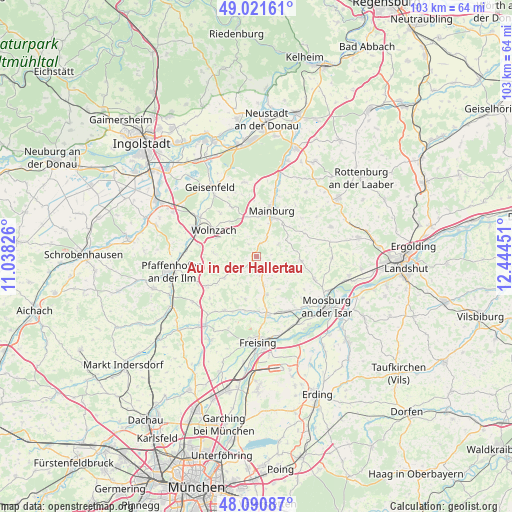
Au in der Hallertau GPS coordinates[2]
48° 33' 30.168" North, 11° 44' 28.968" East
| Map corner | latitude | longitude |
|---|---|---|
| Upper-left | 49.02161°, | 11.03826° |
| Center: | 48.55838°, | 11.74138° |
| Lower-right: | 48.09087°, | 12.44451° |
| Map W x H: | 103.5×103.5 km | = 64.3×64.3mi |
| max Lat: | 55.01917° ⇑88.4% North |
| Au in der Hallertau: | 48.55838° |
| min Lat: | ⇓11.6% South 47.40724° |
| min Long | Au in der Halle | max Long |
| 5.92978° | 11.74138° | 14.98853° |
| W 77.8%⇐ | ⇒22.2% E |
Elevation
Elevation of Au in der Hallertau is 455 m = 1493 ft, and this is 205.9 m = 676 ft above average elevation for this country.
| Max E: |
1256 m = 4121 ft | 16.8% |
| Au in der Hallertau | 455 m 1493 ft | |
| Avg. | 249.1 m = 817 ft | |
Min E: |
-5 m = -16 ft | 83.2% |
See also: Germany elevation on elevation.city.
Geographical zone
Au in der Hallertau is located in North temperate zone (between Tropic of Cancer and the Arctic Circle). Distance of this North polar circle is 2002 km =1244 mi to North.| Distance of | km | miles | from Au in der Hallertau |
|---|---|---|---|
| North Pole | 4607.9 | 2863.2 | to North |
| Arctic Circle | 2002 | 1244 | to North |
| Tropic Cancer | 2793.3 | 1735.7 | to South |
| Equator | 5399.2 | 3354.9 | to South |


Nearby cities:
15 places around Au in der Hallertau: (largest is in red/bold)
• Attenhofen
12.9 km =8 mi,  37°
37°
• Attenkirchen
6.1 km =3.8 mi,  166°
166°
• Haag an der Amper
12.8 km =8 mi,  150°
150°
• Hörgertshausen
9.3 km =5.8 mi,  95°
95°
• Kirchdorf
4.1 km =2.5 mi,  24°
24°
• Kirchdorf
12.7 km =7.9 mi,  210°
210°
• Mainburg
9.7 km =6 mi, 17°
• Mauern
12.6 km =7.8 mi,  111°
111°
• Nandlstadt
5.4 km =3.4 mi,  116°
116°
• Rudelzhausen
5 km =3.1 mi, 21°
• Schweitenkirchen
11.8 km =7.3 mi,  238°
238°
• Volkenschwand
11.4 km =7.1 mi,  66°
66°
• Wolfersdorf
9.1 km =5.7 mi,  194°
194°
• Wolnzach
9.9 km =6.2 mi,  300°
300°
• Zolling
12.2 km =7.6 mi, 171°
Sources, notices
• [Note1] Compared only with cities in Germany existing in our database
• [Src1] Map data: © OpenStreetMap contributors (CC-BY-SA)
• [Src2] Other city data from geonames.org with taken over terms of usage.
• [Src3] Geographical zone / Annual Mean Temperature by Robert A. Rohde @ Wikipedia
