Haag an der Amper geodata
Haag an der Amper (Bavaria) is a populated place; located in Germany in Europe/Berlin (GMT+2) time zone. With population of 2,909 people, there are 4082 cities with bigger population in this country. Compared to other cities in Germany, 89.6% of cities are located further ↑North; 79.3% of cities are located further ←West and 80.7% of cities have lower elevation than Haag an der Amper. Note1
Administrative division(s):
- Level 1: Bavaria
- Level 2: Upper Bavaria
- Level 3: Landkreis Freising
- Level 4: Haag a.d.Amper


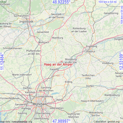
Haag an der Amper GPS coordinates[2]
48° 27' 30.24" North, 11° 49' 40.656" East
| Map corner | latitude | longitude |
|---|---|---|
| Upper-left | 48.92255°, | 11.12484° |
| Center: | 48.4584°, | 11.82796° |
| Lower-right: | 47.98997°, | 12.53109° |
| Map W x H: | 103.7×103.7 km | = 64.4×64.4mi |
| max Lat: | 55.01917° ⇑89.6% North |
| Haag an der Amper: | 48.4584° |
| min Lat: | ⇓10.4% South 47.40724° |
| min Long | Haag an der Amp | max Long |
| 5.92978° | 11.82796° | 14.98853° |
| W 79.3%⇐ | ⇒20.7% E |
Elevation
Elevation of Haag an der Amper is 437 m = 1434 ft, and this is 187.9 m = 616 ft above average elevation for this country.
| Max E: |
1256 m = 4121 ft | 19.3% |
| Haag an der Amper | 437 m 1434 ft | |
| Avg. | 249.1 m = 817 ft | |
Min E: |
-5 m = -16 ft | 80.7% |
See also: Germany elevation on elevation.city.
Geographical zone
Haag an der Amper is located in North temperate zone (between Tropic of Cancer and the Arctic Circle). Distance of this North polar circle is 2013.1 km =1250.9 mi to North.| Distance of | km | miles | from Haag an der Amper |
|---|---|---|---|
| North Pole | 4619 | 2870.1 | to North |
| Arctic Circle | 2013.1 | 1250.9 | to North |
| Tropic Cancer | 2782.2 | 1728.8 | to South |
| Equator | 5388.1 | 3348 | to South |


Nearby cities:
15 places around Haag an der Amper: (largest is in red/bold)
• Attenkirchen
7.2 km =4.5 mi,  316°
316°
• Berglern
11.2 km =7 mi,  137°
137°
• Eitting
11.9 km =7.4 mi,  157°
157°
• Freising
8.4 km =5.2 mi,  223°
223°
• Hörgertshausen
10.6 km =6.6 mi,  15°
15°
• Kirchdorf
12.8 km =8 mi,  270°
270°
• Langenbach
3.2 km =2 mi,  149°
149°
• Langenpreising
11.2 km =7 mi,  108°
108°
• Marzling
6 km =3.7 mi,  204°
204°
• Mauern
8.4 km =5.2 mi,  39°
39°
• Moosburg
8.2 km =5.1 mi,  80°
80°
• Nandlstadt
8.8 km =5.5 mi,  350°
350°
• Wang
9 km =5.6 mi,  62°
62°
• Wolfersdorf
9 km =5.6 mi,  284°
284°
• Zolling
4.6 km =2.9 mi,  258°
258°
Sources, notices
• [Note1] Compared only with cities in Germany existing in our database
• [Src1] Map data: © OpenStreetMap contributors (CC-BY-SA)
• [Src2] Other city data from geonames.org with taken over terms of usage.
• [Src3] Geographical zone / Annual Mean Temperature by Robert A. Rohde @ Wikipedia
