Seligenstadt geodata
Seligenstadt (Hesse) is a populated place; located in Germany in Europe/Berlin (GMT+2) time zone. With population of 19,569 people, there are 791 cities with bigger population in this country. Compared to other cities in Germany, 62.6% of cities are located further ↑North; 65.8% of cities are located further →East and 66.3% of cities have higher elevation than Seligenstadt. Note1
Administrative division(s):
- Level 1: Hesse
- Level 2: Regierungsbezirk Darmstadt
- Level 3: Landkreis Offenbach
- Level 4: Seligenstadt


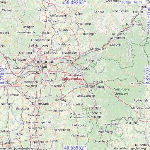
Seligenstadt GPS coordinates[2]
50° 2' 35.52" North, 8° 58' 26.184" East
| Map corner | latitude | longitude |
|---|---|---|
| Upper-left | 50.49263°, | 8.27082° |
| Center: | 50.0432°, | 8.97394° |
| Lower-right: | 49.58952°, | 9.67707° |
| Map W x H: | 100.4×100.4 km | = 62.4×62.4mi |
| max Lat: | 55.01917° ⇑62.6% North |
| Seligenstadt: | 50.0432° |
| min Lat: | ⇓37.4% South 47.40724° |
| min Long | Seligenstadt | max Long |
| 5.92978° | 8.97394° | 14.98853° |
| W 34.2%⇐ | ⇒65.8% E |
Elevation
Elevation of Seligenstadt is 112 m = 367 ft, and this is 137.1 m = 450 ft below average elevation for this country.
| Max E: |
1256 m = 4121 ft | 66.3% |
| Avg. | 249.1 m = 817 ft | |
| Seligenstadt | 112 m = 367 ft | |
Min E: |
-5 m = -16 ft | 33.7% |
See also: Germany elevation on elevation.city.
Geographical zone
Seligenstadt is located in North temperate zone (between Tropic of Cancer and the Arctic Circle). Distance of this North polar circle is 1836.9 km =1141.4 mi to North.| Distance of | km | miles | from Seligenstadt |
|---|---|---|---|
| North Pole | 4442.8 | 2760.6 | to North |
| Arctic Circle | 1836.9 | 1141.4 | to North |
| Tropic Cancer | 2958.4 | 1838.3 | to South |
| Equator | 5564.3 | 3457.5 | to South |


Nearby cities:
15 places around Seligenstadt: (largest is in red/bold)
• Alzenau in Unterfranken
8.2 km =5.1 mi,  51°
51°
• Babenhausen
8.8 km =5.5 mi,  190°
190°
• Erlensee
13.3 km =8.3 mi,  1°
1°
• Großkrotzenburg
4.5 km =2.8 mi,  8°
8°
• Hanau am Main
11 km =6.8 mi,  337°
337°
• Heusenstamm
12.4 km =7.7 mi,  276°
276°
• Johannesberg
12.1 km =7.5 mi,  96°
96°
• Kahl am Main
3.7 km =2.3 mi,  37°
37°
• Kleinostheim
8.2 km =5.1 mi,  125°
125°
• Mainaschaff
10.8 km =6.7 mi, 129°
• Mühlheim am Main
12.9 km =8 mi,  309°
309°
• Obertshausen
9.3 km =5.8 mi,  289°
289°
• Rodenbach
12.6 km =7.8 mi,  19°
19°
• Rodgau
6.6 km =4.1 mi,  253°
253°
• Stockstadt am Main
10.7 km =6.6 mi,  139°
139°
Sources, notices
• [Note1] Compared only with cities in Germany existing in our database
• [Src1] Map data: © OpenStreetMap contributors (CC-BY-SA)
• [Src2] Other city data from geonames.org with taken over terms of usage.
• [Src3] Geographical zone / Annual Mean Temperature by Robert A. Rohde @ Wikipedia
