Dietzenbach geodata
Dietzenbach (Hesse) is a seat of a third-order administrative division; located in Germany in Europe/Berlin (GMT+2) time zone. With population of 33,256 people, there are 408 cities with bigger population in this country. Compared to other cities in Germany, 63.6% of cities are located further ↑North; 68.2% of cities are located further →East and 60% of cities have higher elevation than Dietzenbach. Note1
Administrative division(s):
- Level 1: Hesse
- Level 2: Regierungsbezirk Darmstadt
- Level 3: Landkreis Offenbach
- Level 4: Dietzenbach, Kreisstadt


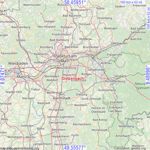
Dietzenbach GPS coordinates[2]
50° 0' 35.136" North, 8° 46' 40.188" East
| Map corner | latitude | longitude |
|---|---|---|
| Upper-left | 50.45951°, | 8.07471° |
| Center: | 50.00976°, | 8.77783° |
| Lower-right: | 49.55577°, | 9.48096° |
| Map W x H: | 100.5×100.5 km | = 62.4×62.4mi |
| max Lat: | 55.01917° ⇑63.6% North |
| Dietzenbach: | 50.00976° |
| min Lat: | ⇓36.4% South 47.40724° |
| min Long | Dietzenbach | max Long |
| 5.92978° | 8.77783° | 14.98853° |
| W 31.8%⇐ | ⇒68.2% E |
Elevation
Elevation of Dietzenbach is 152 m = 499 ft, and this is 97.1 m = 319 ft below average elevation for this country.
| Max E: |
1256 m = 4121 ft | 60% |
| Avg. | 249.1 m = 817 ft | |
| Dietzenbach | 152 m = 499 ft | |
Min E: |
-5 m = -16 ft | 40% |
See also: Germany elevation on elevation.city.
Geographical zone
Dietzenbach is located in North temperate zone (between Tropic of Cancer and the Arctic Circle). Distance of this North polar circle is 1840.6 km =1143.7 mi to North.| Distance of | km | miles | from Dietzenbach |
|---|---|---|---|
| North Pole | 4446.5 | 2762.9 | to North |
| Arctic Circle | 1840.6 | 1143.7 | to North |
| Tropic Cancer | 2954.6 | 1835.9 | to South |
| Equator | 5560.6 | 3455.2 | to South |


Nearby cities:
15 places around Dietzenbach: (largest is in red/bold)
• Babenhausen
13.4 km =8.3 mi,  111°
111°
• Dieburg
13.4 km =8.3 mi,  158°
158°
• Dreieich
5.9 km =3.7 mi,  281°
281°
• Egelsbach
9.4 km =5.8 mi,  240°
240°
• Eppertshausen
8.5 km =5.3 mi,  140°
140°
• Erzhausen
11.1 km =6.9 mi, 236°
• Heusenstamm
5.3 km =3.3 mi,  17°
17°
• Langen
8.1 km =5 mi,  253°
253°
• Messel
8.4 km =5.2 mi,  198°
198°
• Mühlheim am Main
12.5 km =7.8 mi, 18°
• Münster
11.6 km =7.2 mi,  146°
146°
• Neu Isenburg
7.4 km =4.6 mi,  305°
305°
• Obertshausen
8.6 km =5.3 mi,  37°
37°
• Offenbach
10.1 km =6.3 mi,  355°
355°
• Rodgau
7.9 km =4.9 mi,  76°
76°
Sources, notices
• [Note1] Compared only with cities in Germany existing in our database
• [Src1] Map data: © OpenStreetMap contributors (CC-BY-SA)
• [Src2] Other city data from geonames.org with taken over terms of usage.
• [Src3] Geographical zone / Annual Mean Temperature by Robert A. Rohde @ Wikipedia
