Thierhaupten geodata
Thierhaupten (Bavaria) is a populated place; located in Germany in Europe/Berlin (GMT+2) time zone. With population of 3,841 people, there are 3385 cities with bigger population in this country. Compared to other cities in Germany, 88.3% of cities are located further ↑North; 65.6% of cities are located further ←West and 79% of cities have lower elevation than Thierhaupten. Note1
Administrative division(s):
- Level 1: Bavaria
- Level 2: Swabia
- Level 3: Landkreis Augsburg
- Level 4: Thierhaupten, Markt


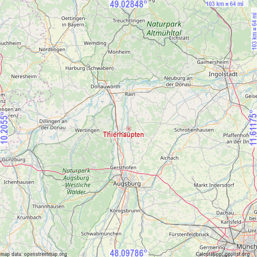
Thierhaupten GPS coordinates[2]
48° 33' 55.116" North, 10° 54' 31.032" East
| Map corner | latitude | longitude |
|---|---|---|
| Upper-left | 49.02848°, | 10.2055° |
| Center: | 48.56531°, | 10.90862° |
| Lower-right: | 48.09786°, | 11.61175° |
| Map W x H: | 103.5×103.5 km | = 64.3×64.3mi |
| max Lat: | 55.01917° ⇑88.3% North |
| Thierhaupten: | 48.56531° |
| min Lat: | ⇓11.7% South 47.40724° |
| min Long | Thierhaupten | max Long |
| 5.92978° | 10.90862° | 14.98853° |
| W 65.6%⇐ | ⇒34.4% E |
Elevation
Elevation of Thierhaupten is 427 m = 1401 ft, and this is 177.9 m = 584 ft above average elevation for this country.
| Max E: |
1256 m = 4121 ft | 21% |
| Thierhaupten | 427 m 1401 ft | |
| Avg. | 249.1 m = 817 ft | |
Min E: |
-5 m = -16 ft | 79% |
See also: Germany elevation on elevation.city.
Geographical zone
Thierhaupten is located in North temperate zone (between Tropic of Cancer and the Arctic Circle). Distance of this North polar circle is 2001.2 km =1243.5 mi to North.| Distance of | km | miles | from Thierhaupten |
|---|---|---|---|
| North Pole | 4607.1 | 2862.7 | to North |
| Arctic Circle | 2001.2 | 1243.5 | to North |
| Tropic Cancer | 2794 | 1736.1 | to South |
| Equator | 5400 | 3355.4 | to South |


Nearby cities:
15 places around Thierhaupten: (largest is in red/bold)
• Aindling
6.6 km =4.1 mi,  150°
150°
• Allmannshofen
9 km =5.6 mi,  305°
305°
• Biberbach
8.9 km =5.5 mi,  233°
233°
• Ehingen
8.9 km =5.5 mi,  295°
295°
• Ellgau
4.9 km =3 mi,  321°
321°
• Holzheim
5.9 km =3.7 mi,  29°
29°
• Kühlenthal
6.8 km =4.2 mi,  271°
271°
• Langweid
9.2 km =5.7 mi,  206°
206°
• Meitingen
4.7 km =2.9 mi,  242°
242°
• Münster
6.4 km =4 mi,  355°
355°
• Nordendorf
6.5 km =4 mi, 300°
• Petersdorf
10.7 km =6.6 mi,  120°
120°
• Rehling
9.3 km =5.8 mi,  168°
168°
• Todtenweis
5.6 km =3.5 mi,  164°
164°
• Westendorf
5.1 km =3.2 mi,  278°
278°
Sources, notices
• [Note1] Compared only with cities in Germany existing in our database
• [Src1] Map data: © OpenStreetMap contributors (CC-BY-SA)
• [Src2] Other city data from geonames.org with taken over terms of usage.
• [Src3] Geographical zone / Annual Mean Temperature by Robert A. Rohde @ Wikipedia
