Metten geodata
Metten (Bavaria) is a populated place; located in Germany in Europe/Berlin (GMT+2) time zone. With population of 4,335 people, there are 3115 cities with bigger population in this country. Compared to other cities in Germany, 84.6% of cities are located further ↑North; 91.6% of cities are located further ←West and 64.3% of cities have lower elevation than Metten. Note1
Administrative division(s):
- Level 1: Bavaria
- Level 2: Lower Bavaria
- Level 3: Landkreis Deggendorf
- Level 4: Metten, Markt


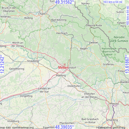
Metten GPS coordinates[2]
48° 51' 18.432" North, 12° 54' 55.944" East
| Map corner | latitude | longitude |
|---|---|---|
| Upper-left | 49.31562°, | 12.21242° |
| Center: | 48.85512°, | 12.91554° |
| Lower-right: | 48.39035°, | 13.61867° |
| Map W x H: | 102.9×102.9 km | = 63.9×63.9mi |
| max Lat: | 55.01917° ⇑84.6% North |
| Metten: | 48.85512° |
| min Lat: | ⇓15.4% South 47.40724° |
| min Long | Metten | max Long |
| 5.92978° | 12.91554° | 14.98853° |
| W 91.6%⇐ | ⇒8.4% E |
Elevation
Elevation of Metten is 317 m = 1040 ft, and this is 67.9 m = 223 ft above average elevation for this country.
| Max E: |
1256 m = 4121 ft | 35.7% |
| Metten | 317 m 1040 ft | |
| Avg. | 249.1 m = 817 ft | |
Min E: |
-5 m = -16 ft | 64.3% |
See also: Germany elevation on elevation.city.
Geographical zone
Metten is located in North temperate zone (between Tropic of Cancer and the Arctic Circle). Distance of this North polar circle is 1969 km =1223.5 mi to North.| Distance of | km | miles | from Metten |
|---|---|---|---|
| North Pole | 4574.9 | 2842.7 | to North |
| Arctic Circle | 1969 | 1223.5 | to North |
| Tropic Cancer | 2826.3 | 1756.2 | to South |
| Equator | 5432.2 | 3375.4 | to South |


Nearby cities:
15 places around Metten: (largest is in red/bold)
• Achslach
13 km =8.1 mi,  6°
6°
• Bernried
7.2 km =4.5 mi,  341°
341°
• Böbrach
9 km =5.6 mi, 344°
• Deggendorf
3.7 km =2.3 mi,  115°
115°
• Grafling
6.2 km =3.9 mi,  44°
44°
• Irlbach
12.1 km =7.5 mi,  262°
262°
• Mariaposching
8.8 km =5.5 mi,  254°
254°
• Moos
12 km =7.5 mi,  163°
163°
• Niederalteich
12.7 km =7.9 mi,  141°
141°
• Niederwinkling
9 km =5.6 mi,  290°
290°
• Offenberg
3.9 km =2.4 mi,  281°
281°
• Plattling
9 km =5.6 mi,  199°
199°
• Schaufling
11.1 km =6.9 mi,  92°
92°
• Schwarzach
10.2 km =6.3 mi,  311°
311°
• Stephansposching
9.5 km =5.9 mi,  243°
243°
Sources, notices
• [Note1] Compared only with cities in Germany existing in our database
• [Src1] Map data: © OpenStreetMap contributors (CC-BY-SA)
• [Src2] Other city data from geonames.org with taken over terms of usage.
• [Src3] Geographical zone / Annual Mean Temperature by Robert A. Rohde @ Wikipedia
