Plattling geodata
Plattling (Bavaria) is a populated place; located in Germany in Europe/Berlin (GMT+2) time zone. With population of 12,390 people, there are 1314 cities with bigger population in this country. Compared to other cities in Germany, 85.6% of cities are located further ↑North; 91.3% of cities are located further ←West and 64.7% of cities have lower elevation than Plattling. Note1
Administrative division(s):
- Level 1: Bavaria
- Level 2: Lower Bavaria
- Level 3: Landkreis Deggendorf
- Level 4: Plattling


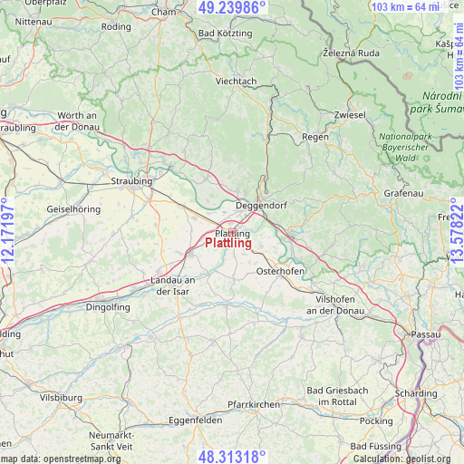
Plattling GPS coordinates[2]
48° 46' 43.176" North, 12° 52' 30.324" East
| Map corner | latitude | longitude |
|---|---|---|
| Upper-left | 49.23986°, | 12.17197° |
| Center: | 48.77866°, | 12.87509° |
| Lower-right: | 48.31318°, | 13.57822° |
| Map W x H: | 103×103 km | = 64×64mi |
| max Lat: | 55.01917° ⇑85.6% North |
| Plattling: | 48.77866° |
| min Lat: | ⇓14.4% South 47.40724° |
| min Long | Plattling | max Long |
| 5.92978° | 12.87509° | 14.98853° |
| W 91.3%⇐ | ⇒8.7% E |
Elevation
Elevation of Plattling is 319 m = 1047 ft, and this is 69.9 m = 229 ft above average elevation for this country.
| Max E: |
1256 m = 4121 ft | 35.3% |
| Plattling | 319 m 1047 ft | |
| Avg. | 249.1 m = 817 ft | |
Min E: |
-5 m = -16 ft | 64.7% |
See also: Germany elevation on elevation.city.
Geographical zone
Plattling is located in North temperate zone (between Tropic of Cancer and the Arctic Circle). Distance of this North polar circle is 1977.5 km =1228.8 mi to North.| Distance of | km | miles | from Plattling |
|---|---|---|---|
| North Pole | 4583.4 | 2848 | to North |
| Arctic Circle | 1977.5 | 1228.8 | to North |
| Tropic Cancer | 2817.8 | 1750.9 | to South |
| Equator | 5423.7 | 3370.1 | to South |


Nearby cities:
15 places around Plattling: (largest is in red/bold)
• Aholming
5.4 km =3.4 mi,  151°
151°
• Buchhofen
9.8 km =6.1 mi,  158°
158°
• Deggendorf
9.3 km =5.8 mi,  42°
42°
• Irlbach
11.4 km =7.1 mi,  307°
307°
• Mariaposching
8.2 km =5.1 mi,  317°
317°
• Metten
9 km =5.6 mi,  19°
19°
• Moos
7 km =4.3 mi,  115°
115°
• Niederalteich
11 km =6.8 mi,  97°
97°
• Oberpöring
9.3 km =5.8 mi,  203°
203°
• Offenberg
9.3 km =5.8 mi,  354°
354°
• Otzing
5.2 km =3.2 mi,  248°
248°
• Stephansposching
6.9 km =4.3 mi, 307°
• Straßkirchen
12.7 km =7.9 mi,  297°
297°
• Wallerfing
10.5 km =6.5 mi,  177°
177°
• Wallersdorf
10.4 km =6.5 mi,  244°
244°
Sources, notices
• [Note1] Compared only with cities in Germany existing in our database
• [Src1] Map data: © OpenStreetMap contributors (CC-BY-SA)
• [Src2] Other city data from geonames.org with taken over terms of usage.
• [Src3] Geographical zone / Annual Mean Temperature by Robert A. Rohde @ Wikipedia
