Grafling geodata
Grafling (Bavaria) is a seat of a fourth-order administrative division; located in Germany in Europe/Berlin (GMT+2) time zone. In our database, there are 11009 cities with bigger population. Compared to other cities in Germany, 84.1% of cities are located further ↑North; 92.1% of cities are located further ←West and 79.9% of cities have lower elevation than Grafling. Note1
Administrative division(s):
- Level 1: Bavaria
- Level 2: Lower Bavaria
- Level 3: Landkreis Deggendorf
- Level 4: Grafling


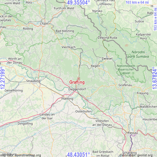
Grafling GPS coordinates[2]
48° 53' 41.676" North, 12° 58' 30.396" East
| Map corner | latitude | longitude |
|---|---|---|
| Upper-left | 49.35504°, | 12.27199° |
| Center: | 48.89491°, | 12.97511° |
| Lower-right: | 48.43051°, | 13.67824° |
| Map W x H: | 102.8×102.8 km | = 63.9×63.9mi |
| max Lat: | 55.01917° ⇑84.1% North |
| Grafling: | 48.89491° |
| min Lat: | ⇓15.9% South 47.40724° |
| min Long | Grafling | max Long |
| 5.92978° | 12.97511° | 14.98853° |
| W 92.1%⇐ | ⇒7.9% E |
Elevation
Elevation of Grafling is 432 m = 1417 ft, and this is 182.9 m = 600 ft above average elevation for this country.
| Max E: |
1256 m = 4121 ft | 20.1% |
| Grafling | 432 m 1417 ft | |
| Avg. | 249.1 m = 817 ft | |
Min E: |
-5 m = -16 ft | 79.9% |
See also: Germany elevation on elevation.city.
Geographical zone
Grafling is located in North temperate zone (between Tropic of Cancer and the Arctic Circle). Distance of this North polar circle is 1964.6 km =1220.7 mi to North.| Distance of | km | miles | from Grafling |
|---|---|---|---|
| North Pole | 4570.5 | 2840 | to North |
| Arctic Circle | 1964.6 | 1220.7 | to North |
| Tropic Cancer | 2830.7 | 1758.9 | to South |
| Equator | 5436.6 | 3378.1 | to South |


Nearby cities:
15 places around Grafling: (largest is in red/bold)
• Achslach
9 km =5.6 mi,  341°
341°
• Bernried
7.1 km =4.4 mi,  289°
289°
• Bischofsmais
8.2 km =5.1 mi,  71°
71°
• Böbrach
8 km =5 mi,  302°
302°
• Deggendorf
6.1 km =3.8 mi,  189°
189°
• Gotteszell
8 km =5 mi,  355°
355°
• Lalling
13.3 km =8.3 mi,  114°
114°
• Metten
6.2 km =3.9 mi,  224°
224°
• Niederwinkling
12.9 km =8 mi,  264°
264°
• Offenberg
9 km =5.6 mi,  245°
245°
• Patersdorf
13.6 km =8.5 mi,  2°
2°
• Ruhmannsfelden
9.8 km =6.1 mi, 3°
• Schaufling
8.4 km =5.2 mi,  126°
126°
• Schwarzach
12.2 km =7.6 mi,  280°
280°
• Zachenberg
8.2 km =5.1 mi,  12°
12°
Sources, notices
• [Note1] Compared only with cities in Germany existing in our database
• [Src1] Map data: © OpenStreetMap contributors (CC-BY-SA)
• [Src2] Other city data from geonames.org with taken over terms of usage.
• [Src3] Geographical zone / Annual Mean Temperature by Robert A. Rohde @ Wikipedia
