Deggendorf geodata
Deggendorf (Bavaria) is a seat of a third-order administrative division; located in Germany in Europe/Berlin (GMT+2) time zone. With population of 31,081 people, there are 448 cities with bigger population in this country. Compared to other cities in Germany, 84.8% of cities are located further ↑North; 92% of cities are located further ←West and 64.9% of cities have lower elevation than Deggendorf. Note1
Administrative division(s):
- Level 1: Bavaria
- Level 2: Lower Bavaria
- Level 3: Landkreis Deggendorf
- Level 4: Deggendorf


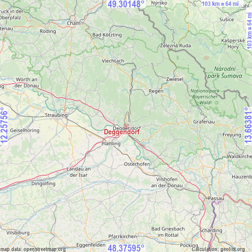
Deggendorf GPS coordinates[2]
48° 50' 27.06" North, 12° 57' 38.448" East
| Map corner | latitude | longitude |
|---|---|---|
| Upper-left | 49.30148°, | 12.25756° |
| Center: | 48.84085°, | 12.96068° |
| Lower-right: | 48.37595°, | 13.66381° |
| Map W x H: | 102.9×102.9 km | = 63.9×63.9mi |
| max Lat: | 55.01917° ⇑84.8% North |
| Deggendorf: | 48.84085° |
| min Lat: | ⇓15.2% South 47.40724° |
| min Long | Deggendorf | max Long |
| 5.92978° | 12.96068° | 14.98853° |
| W 92%⇐ | ⇒8% E |
Elevation
Elevation of Deggendorf is 320 m = 1050 ft, and this is 70.9 m = 233 ft above average elevation for this country.
| Max E: |
1256 m = 4121 ft | 35.1% |
| Deggendorf | 320 m 1050 ft | |
| Avg. | 249.1 m = 817 ft | |
Min E: |
-5 m = -16 ft | 64.9% |
See also: Germany elevation on elevation.city.
Geographical zone
Deggendorf is located in North temperate zone (between Tropic of Cancer and the Arctic Circle). Distance of this North polar circle is 1970.6 km =1224.5 mi to North.| Distance of | km | miles | from Deggendorf |
|---|---|---|---|
| North Pole | 4576.5 | 2843.7 | to North |
| Arctic Circle | 1970.6 | 1224.5 | to North |
| Tropic Cancer | 2824.7 | 1755.2 | to South |
| Equator | 5430.6 | 3374.4 | to South |


Nearby cities:
15 places around Deggendorf: (largest is in red/bold)
• Aholming
12.3 km =7.6 mi,  197°
197°
• Auerbach
11 km =6.8 mi,  112°
112°
• Bernried
10.2 km =6.3 mi,  326°
326°
• Bischofsmais
12.3 km =7.6 mi,  45°
45°
• Böbrach
11.7 km =7.3 mi, 331°
• Grafling
6.1 km =3.8 mi,  9°
9°
• Hengersberg
10.3 km =6.4 mi,  137°
137°
• Mariaposching
11.8 km =7.3 mi,  265°
265°
• Metten
3.7 km =2.3 mi,  295°
295°
• Moos
9.9 km =6.2 mi,  179°
179°
• Niederalteich
9.6 km =6 mi,  150°
150°
• Offenberg
7.5 km =4.7 mi,  288°
288°
• Plattling
9.3 km =5.8 mi,  222°
222°
• Schaufling
7.8 km =4.8 mi,  82°
82°
• Stephansposching
12.1 km =7.5 mi,  257°
257°
Sources, notices
• [Note1] Compared only with cities in Germany existing in our database
• [Src1] Map data: © OpenStreetMap contributors (CC-BY-SA)
• [Src2] Other city data from geonames.org with taken over terms of usage.
• [Src3] Geographical zone / Annual Mean Temperature by Robert A. Rohde @ Wikipedia
