Moos geodata
Moos (Bavaria) is a seat of a fourth-order administrative division; located in Germany in Europe/Berlin (GMT+2) time zone. In our database, there are 11009 cities with bigger population. Compared to other cities in Germany, 85.9% of cities are located further ↑North; 92% of cities are located further ←West and 64% of cities have lower elevation than Moos. Note1
Administrative division(s):
- Level 1: Bavaria
- Level 2: Lower Bavaria
- Level 3: Landkreis Deggendorf
- Level 4: Moos


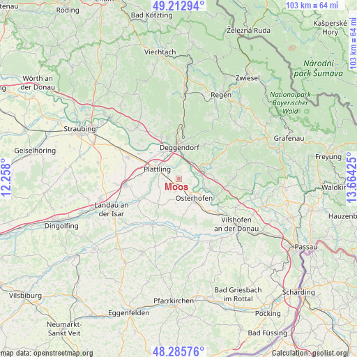
Moos GPS coordinates[2]
48° 45' 5.364" North, 12° 57' 40.032" East
| Map corner | latitude | longitude |
|---|---|---|
| Upper-left | 49.21294°, | 12.258° |
| Center: | 48.75149°, | 12.96112° |
| Lower-right: | 48.28576°, | 13.66425° |
| Map W x H: | 103.1×103.1 km | = 64.1×64.1mi |
| max Lat: | 55.01917° ⇑85.9% North |
| Moos: | 48.75149° |
| min Lat: | ⇓14.1% South 47.40724° |
| min Long | Moos | max Long |
| 5.92978° | 12.96112° | 14.98853° |
| W 92%⇐ | ⇒8% E |
Elevation
Elevation of Moos is 315 m = 1033 ft, and this is 65.9 m = 216 ft above average elevation for this country.
| Max E: |
1256 m = 4121 ft | 36% |
| Moos | 315 m 1033 ft | |
| Avg. | 249.1 m = 817 ft | |
Min E: |
-5 m = -16 ft | 64% |
See also: Germany elevation on elevation.city.
Geographical zone
Moos is located in North temperate zone (between Tropic of Cancer and the Arctic Circle). Distance of this North polar circle is 1980.5 km =1230.6 mi to North.| Distance of | km | miles | from Moos |
|---|---|---|---|
| North Pole | 4586.4 | 2849.9 | to North |
| Arctic Circle | 1980.5 | 1230.6 | to North |
| Tropic Cancer | 2814.7 | 1749 | to South |
| Equator | 5420.7 | 3368.3 | to South |


Nearby cities:
15 places around Moos: (largest is in red/bold)
• Aholming
4.2 km =2.6 mi,  244°
244°
• Auerbach
11.7 km =7.3 mi,  60°
60°
• Buchhofen
6.6 km =4.1 mi,  203°
203°
• Deggendorf
9.9 km =6.2 mi,  359°
359°
• Hengersberg
7.3 km =4.5 mi,  71°
71°
• Künzing
13 km =8.1 mi,  136°
136°
• Metten
12 km =7.5 mi,  343°
343°
• Niederalteich
4.9 km =3 mi, 71°
• Oberpöring
11.4 km =7.1 mi, 241°
• Osterhofen
7.3 km =4.5 mi, 141°
• Otzing
11.2 km =7 mi,  275°
275°
• Plattling
7 km =4.3 mi,  295°
295°
• Schaufling
13.4 km =8.3 mi,  35°
35°
• Wallerfing
9.5 km =5.9 mi,  218°
218°
• Winzer
9.1 km =5.7 mi,  110°
110°
Sources, notices
• [Note1] Compared only with cities in Germany existing in our database
• [Src1] Map data: © OpenStreetMap contributors (CC-BY-SA)
• [Src2] Other city data from geonames.org with taken over terms of usage.
• [Src3] Geographical zone / Annual Mean Temperature by Robert A. Rohde @ Wikipedia
