Alheim geodata
Alheim (Hesse) is a seat of a fourth-order administrative division; located in Germany in Europe/Berlin (GMT+2) time zone. With population of 5,292 people, there are 2702 cities with bigger population in this country. Compared to other cities in Germany, 58.6% of cities are located further ↓South; 55% of cities are located further →East and 56.3% of cities have higher elevation than Alheim. Note1
Administrative division(s):
- Level 1: Hesse
- Level 2: Regierungsbezirk Kassel
- Level 3: Landkreis Hersfeld-Rotenburg
- Level 4: Alheim


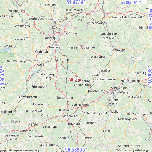
Alheim GPS coordinates[2]
51° 1' 59.988" North, 9° 40' 0.012" East
| Map corner | latitude | longitude |
|---|---|---|
| Upper-left | 51.4734°, | 8.96355° |
| Center: | 51.03333°, | 9.66667° |
| Lower-right: | 50.58905°, | 10.3698° |
| Map W x H: | 98.3×98.3 km | = 61.1×61.1mi |
| max Lat: | 55.01917° ⇑41.4% North |
| Alheim: | 51.03333° |
| min Lat: | ⇓58.6% South 47.40724° |
| min Long | Alheim | max Long |
| 5.92978° | 9.66667° | 14.98853° |
| W 45%⇐ | ⇒55% E |
Elevation
Elevation of Alheim is 179 m = 587 ft, and this is 70.1 m = 230 ft below average elevation for this country.
| Max E: |
1256 m = 4121 ft | 56.3% |
| Avg. | 249.1 m = 817 ft | |
| Alheim | 179 m = 587 ft | |
Min E: |
-5 m = -16 ft | 43.7% |
See also: Germany elevation on elevation.city.
Geographical zone
Alheim is located in North temperate zone (between Tropic of Cancer and the Arctic Circle). Distance of this North polar circle is 1726.8 km =1073 mi to North.| Distance of | km | miles | from Alheim |
|---|---|---|---|
| North Pole | 4332.7 | 2692.2 | to North |
| Arctic Circle | 1726.8 | 1073 | to North |
| Tropic Cancer | 3068.5 | 1906.7 | to South |
| Equator | 5674.4 | 3525.9 | to South |


Nearby cities:
15 places around Alheim: (largest is in red/bold)
• Bad Hersfeld
18.2 km =11.3 mi,  170°
170°
• Bebra
11.1 km =6.9 mi,  125°
125°
• Breitenbach
11.8 km =7.3 mi,  136°
136°
• Cornberg
13.6 km =8.5 mi,  86°
86°
• Hessisch Lichtenau
18.8 km =11.7 mi,  11°
11°
• Homberg
18.5 km =11.5 mi,  268°
268°
• Körle
18.2 km =11.3 mi,  324°
324°
• Malsfeld
11 km =6.8 mi,  305°
305°
• Melsungen
13.4 km =8.3 mi, 323°
• Nentershausen
18.7 km =11.6 mi,  95°
95°
• Ronshausen
15.8 km =9.8 mi, 125°
• Rotenburg an der Fulda
6 km =3.7 mi, 134°
• Sontra
19.3 km =12 mi,  77°
77°
• Spangenberg
9.2 km =5.7 mi,  358°
358°
• Waldkappel
19.2 km =11.9 mi,  49°
49°
Sources, notices
• [Note1] Compared only with cities in Germany existing in our database
• [Src1] Map data: © OpenStreetMap contributors (CC-BY-SA)
• [Src2] Other city data from geonames.org with taken over terms of usage.
• [Src3] Geographical zone / Annual Mean Temperature by Robert A. Rohde @ Wikipedia
