Malsfeld geodata
Malsfeld (Hesse) is a seat of a fourth-order administrative division; located in Germany in Europe/Berlin (GMT+2) time zone. With population of 4,301 people, there are 3132 cities with bigger population in this country. Compared to other cities in Germany, 59.7% of cities are located further ↓South; 57.1% of cities are located further →East and 55.4% of cities have higher elevation than Malsfeld. Note1
Administrative division(s):
- Level 1: Hesse
- Level 2: Regierungsbezirk Kassel
- Level 3: Schwalm-Eder-Kreis
- Level 4: Malsfeld


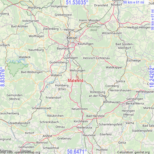
Malsfeld GPS coordinates[2]
51° 5' 26.988" North, 9° 32' 20.004" East
| Map corner | latitude | longitude |
|---|---|---|
| Upper-left | 51.53035°, | 8.83576° |
| Center: | 51.09083°, | 9.53889° |
| Lower-right: | 50.6471°, | 10.24202° |
| Map W x H: | 98.2×98.2 km | = 61×61mi |
| max Lat: | 55.01917° ⇑40.3% North |
| Malsfeld: | 51.09083° |
| min Lat: | ⇓59.7% South 47.40724° |
| min Long | Malsfeld | max Long |
| 5.92978° | 9.53889° | 14.98853° |
| W 42.9%⇐ | ⇒57.1% E |
Elevation
Elevation of Malsfeld is 186 m = 610 ft, and this is 63.1 m = 207 ft below average elevation for this country.
| Max E: |
1256 m = 4121 ft | 55.4% |
| Avg. | 249.1 m = 817 ft | |
| Malsfeld | 186 m = 610 ft | |
Min E: |
-5 m = -16 ft | 44.6% |
See also: Germany elevation on elevation.city.
Geographical zone
Malsfeld is located in North temperate zone (between Tropic of Cancer and the Arctic Circle). Distance of this North polar circle is 1720.4 km =1069 mi to North.| Distance of | km | miles | from Malsfeld |
|---|---|---|---|
| North Pole | 4326.3 | 2688.2 | to North |
| Arctic Circle | 1720.4 | 1069 | to North |
| Tropic Cancer | 3074.8 | 1910.6 | to South |
| Equator | 5680.8 | 3529.9 | to South |


Nearby cities:
15 places around Malsfeld: (largest is in red/bold)
• Alheim
11 km =6.8 mi,  125°
125°
• Borken
18.5 km =11.5 mi,  254°
254°
• Felsberg
9.7 km =6 mi,  302°
302°
• Fritzlar
18.9 km =11.7 mi,  283°
283°
• Fuldabrück
19.9 km =12.4 mi,  348°
348°
• Gudensberg
15.3 km =9.5 mi,  308°
308°
• Guxhagen
12.7 km =7.9 mi,  342°
342°
• Hessisch Lichtenau
17.4 km =10.8 mi,  46°
46°
• Homberg
11.7 km =7.3 mi,  234°
234°
• Körle
8.6 km =5.3 mi, 349°
• Lohfelden
19.6 km =12.2 mi,  358°
358°
• Melsungen
4.5 km =2.8 mi,  12°
12°
• Rotenburg an der Fulda
17 km =10.6 mi, 128°
• Spangenberg
9.1 km =5.7 mi,  71°
71°
• Wabern
13.2 km =8.2 mi,  274°
274°
Sources, notices
• [Note1] Compared only with cities in Germany existing in our database
• [Src1] Map data: © OpenStreetMap contributors (CC-BY-SA)
• [Src2] Other city data from geonames.org with taken over terms of usage.
• [Src3] Geographical zone / Annual Mean Temperature by Robert A. Rohde @ Wikipedia
