Spangenberg geodata
Spangenberg (Hesse) is a populated place; located in Germany in Europe/Berlin (GMT+2) time zone. With population of 6,570 people, there are 2287 cities with bigger population in this country. Compared to other cities in Germany, 60.1% of cities are located further ↓South; 55.1% of cities are located further →East and 51.6% of cities have lower elevation than Spangenberg. Note1
Administrative division(s):
- Level 1: Hesse
- Level 2: Regierungsbezirk Kassel
- Level 3: Schwalm-Eder-Kreis
- Level 4: Spangenberg, Liebenbachstadt


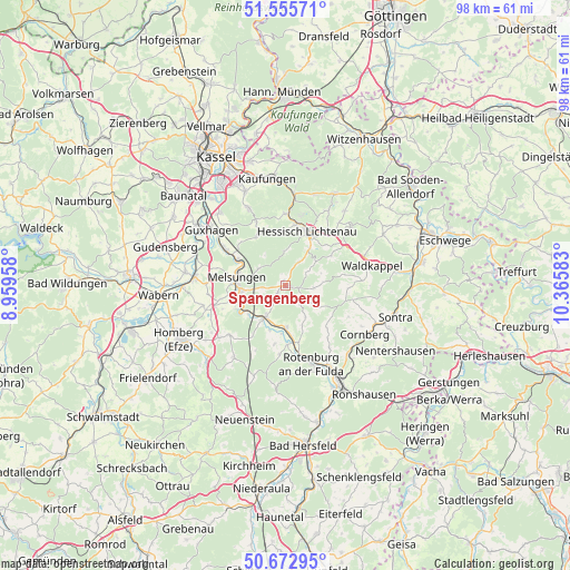
Spangenberg GPS coordinates[2]
51° 6' 59.184" North, 9° 39' 45.72" East
| Map corner | latitude | longitude |
|---|---|---|
| Upper-left | 51.55571°, | 8.95958° |
| Center: | 51.11644°, | 9.6627° |
| Lower-right: | 50.67295°, | 10.36583° |
| Map W x H: | 98.2×98.2 km | = 61×61mi |
| max Lat: | 55.01917° ⇑39.9% North |
| Spangenberg: | 51.11644° |
| min Lat: | ⇓60.1% South 47.40724° |
| min Long | Spangenberg | max Long |
| 5.92978° | 9.6627° | 14.98853° |
| W 44.9%⇐ | ⇒55.1% E |
Elevation
Elevation of Spangenberg is 237 m = 778 ft, and this is 12.1 m = 40 ft below average elevation for this country.
| Max E: |
1256 m = 4121 ft | 48.4% |
| Avg. | 249.1 m = 817 ft | |
| Spangenberg | 237 m = 778 ft | |
Min E: |
-5 m = -16 ft | 51.6% |
See also: Germany elevation on elevation.city.
Geographical zone
Spangenberg is located in North temperate zone (between Tropic of Cancer and the Arctic Circle). Distance of this North polar circle is 1717.6 km =1067.3 mi to North.| Distance of | km | miles | from Spangenberg |
|---|---|---|---|
| North Pole | 4323.4 | 2686.4 | to North |
| Arctic Circle | 1717.6 | 1067.3 | to North |
| Tropic Cancer | 3077.7 | 1912.4 | to South |
| Equator | 5683.6 | 3531.6 | to South |


Nearby cities:
15 places around Spangenberg: (largest is in red/bold)
• Alheim
9.2 km =5.7 mi,  178°
178°
• Bebra
18.3 km =11.4 mi,  149°
149°
• Cornberg
16.1 km =10 mi,  121°
121°
• Felsberg
17 km =10.6 mi,  277°
277°
• Großalmerode
17.9 km =11.1 mi,  28°
28°
• Guxhagen
15.6 km =9.7 mi,  306°
306°
• Helsa
16 km =9.9 mi,  6°
6°
• Hessisch Lichtenau
10 km =6.2 mi,  22°
22°
• Kaufungen
18.6 km =11.6 mi,  350°
350°
• Körle
11.6 km =7.2 mi,  298°
298°
• Lohfelden
19 km =11.8 mi,  331°
331°
• Malsfeld
9.1 km =5.7 mi,  251°
251°
• Melsungen
7.9 km =4.9 mi, 281°
• Rotenburg an der Fulda
14.2 km =8.8 mi,  161°
161°
• Waldkappel
15.3 km =9.5 mi,  78°
78°
Sources, notices
• [Note1] Compared only with cities in Germany existing in our database
• [Src1] Map data: © OpenStreetMap contributors (CC-BY-SA)
• [Src2] Other city data from geonames.org with taken over terms of usage.
• [Src3] Geographical zone / Annual Mean Temperature by Robert A. Rohde @ Wikipedia
