Langlingen geodata
Langlingen (Lower Saxony) is a populated place; located in Germany in Europe/Berlin (GMT+2) time zone. With population of 2,303 people, there are 4668 cities with bigger population in this country. Compared to other cities in Germany, 78.2% of cities are located further ↓South; 54.9% of cities are located further ←West and 79.9% of cities have higher elevation than Langlingen. Note1


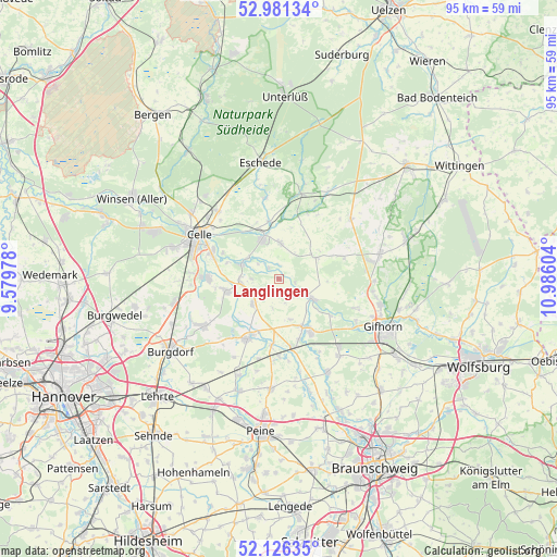
Langlingen GPS coordinates[2]
52° 33' 21.348" North, 10° 16' 58.476" East
| Map corner | latitude | longitude |
|---|---|---|
| Upper-left | 52.98134°, | 9.57978° |
| Center: | 52.55593°, | 10.28291° |
| Lower-right: | 52.12635°, | 10.98604° |
| Map W x H: | 95.1×95.1 km | = 59.1×59.1mi |
| max Lat: | 55.01917° ⇑21.8% North |
| Langlingen: | 52.55593° |
| min Lat: | ⇓78.2% South 47.40724° |
| min Long | Langlingen | max Long |
| 5.92978° | 10.28291° | 14.98853° |
| W 54.9%⇐ | ⇒45.1% E |
Elevation
Elevation of Langlingen is 47 m = 154 ft, and this is 202.1 m = 663 ft below average elevation for this country.
| Max E: |
1256 m = 4121 ft | 79.9% |
| Avg. | 249.1 m = 817 ft | |
| Langlingen | 47 m = 154 ft | |
Min E: |
-5 m = -16 ft | 20.1% |
See also: Germany elevation on elevation.city.
Geographical zone
Langlingen is located in North temperate zone (between Tropic of Cancer and the Arctic Circle). Distance of this North polar circle is 1557.5 km =967.8 mi to North.| Distance of | km | miles | from Langlingen |
|---|---|---|---|
| North Pole | 4163.4 | 2587 | to North |
| Arctic Circle | 1557.5 | 967.8 | to North |
| Tropic Cancer | 3237.8 | 2011.9 | to South |
| Equator | 5843.7 | 3631.1 | to South |


Nearby cities:
15 places around Langlingen: (largest is in red/bold)
• Ahnsbeck
6.1 km =3.8 mi,  1°
1°
• Altmerdingsen
14.5 km =9 mi,  225°
225°
• Beedenbostel
9.8 km =6.1 mi,  350°
350°
• Bröckel
6.4 km =4 mi, 226°
• Eicklingen
6.7 km =4.2 mi,  264°
264°
• Hohne
7.2 km =4.5 mi,  61°
61°
• Höfer
14.3 km =8.9 mi, 351°
• Lachendorf
7.1 km =4.4 mi,  341°
341°
• Meinersen
10.2 km =6.3 mi,  152°
152°
• Müden
6.1 km =3.8 mi,  121°
121°
• Nienhagen
12.2 km =7.6 mi,  270°
270°
• Uetze
11.4 km =7.1 mi,  207°
207°
• Ummern
10.8 km =6.7 mi,  68°
68°
• Wathlingen
9.2 km =5.7 mi, 256°
• Wienhausen
6.9 km =4.3 mi,  292°
292°
Sources, notices
• [Note1] Compared only with cities in Germany existing in our database
• [Src1] Map data: © OpenStreetMap contributors (CC-BY-SA)
• [Src2] Other city data from geonames.org with taken over terms of usage.
• [Src3] Geographical zone / Annual Mean Temperature by Robert A. Rohde @ Wikipedia
