Hohne geodata
Hohne (Lower Saxony) is a seat of a fourth-order administrative division; located in Germany in Europe/Berlin (GMT+2) time zone. In our database, there are 11009 cities with bigger population. Compared to other cities in Germany, 78.6% of cities are located further ↓South; 56.8% of cities are located further ←West and 77.3% of cities have higher elevation than Hohne. Note1


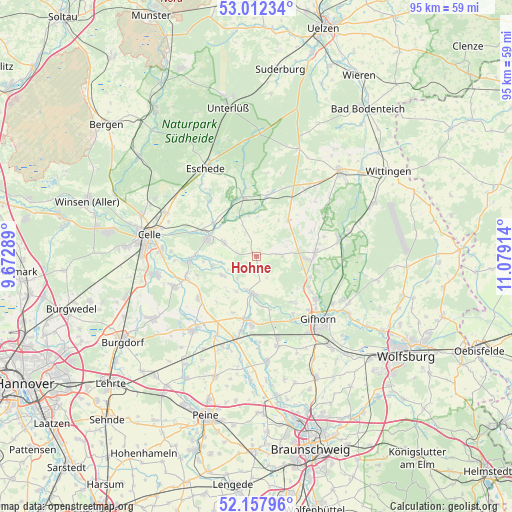
Hohne GPS coordinates[2]
52° 35' 14.028" North, 10° 22' 33.636" East
| Map corner | latitude | longitude |
|---|---|---|
| Upper-left | 53.01234°, | 9.67289° |
| Center: | 52.58723°, | 10.37601° |
| Lower-right: | 52.15796°, | 11.07914° |
| Map W x H: | 95×95 km | = 59×59mi |
| max Lat: | 55.01917° ⇑21.4% North |
| Hohne: | 52.58723° |
| min Lat: | ⇓78.6% South 47.40724° |
| min Long | Hohne | max Long |
| 5.92978° | 10.37601° | 14.98853° |
| W 56.8%⇐ | ⇒43.2% E |
Elevation
Elevation of Hohne is 55 m = 180 ft, and this is 194.1 m = 637 ft below average elevation for this country.
| Max E: |
1256 m = 4121 ft | 77.3% |
| Avg. | 249.1 m = 817 ft | |
| Hohne | 55 m = 180 ft | |
Min E: |
-5 m = -16 ft | 22.7% |
See also: Germany elevation on elevation.city.
Geographical zone
Hohne is located in North temperate zone (between Tropic of Cancer and the Arctic Circle). Distance of this North polar circle is 1554 km =965.6 mi to North.| Distance of | km | miles | from Hohne |
|---|---|---|---|
| North Pole | 4159.9 | 2584.8 | to North |
| Arctic Circle | 1554 | 965.6 | to North |
| Tropic Cancer | 3241.2 | 2014 | to South |
| Equator | 5847.2 | 3633.3 | to South |


Nearby cities:
15 places around Hohne: (largest is in red/bold)
• Ahnsbeck
6.7 km =4.2 mi,  293°
293°
• Beedenbostel
10 km =6.2 mi,  308°
308°
• Bröckel
13.4 km =8.3 mi,  234°
234°
• Eicklingen
13.6 km =8.5 mi,  252°
252°
• Eldingen
11.1 km =6.9 mi,  344°
344°
• Groß Oesingen
8.9 km =5.5 mi,  41°
41°
• Lachendorf
9.1 km =5.7 mi, 291°
• Langlingen
7.2 km =4.5 mi,  241°
241°
• Meinersen
12.7 km =7.9 mi,  187°
187°
• Müden
6.7 km =4.2 mi, 189°
• Steinhorst
10.8 km =6.7 mi,  8°
8°
• Ummern
3.8 km =2.4 mi,  83°
83°
• Wagenhoff
10.7 km =6.6 mi,  111°
111°
• Wesendorf
10.7 km =6.6 mi, 82°
• Wienhausen
12.7 km =7.9 mi,  266°
266°
Sources, notices
• [Note1] Compared only with cities in Germany existing in our database
• [Src1] Map data: © OpenStreetMap contributors (CC-BY-SA)
• [Src2] Other city data from geonames.org with taken over terms of usage.
• [Src3] Geographical zone / Annual Mean Temperature by Robert A. Rohde @ Wikipedia
