Hohenlinden geodata
Hohenlinden (Bavaria) is a seat of a fourth-order administrative division; located in Germany in Europe/Berlin (GMT+2) time zone. With population of 2,769 people, there are 4180 cities with bigger population in this country. Compared to other cities in Germany, 93.3% of cities are located further ↑North; 81.7% of cities are located further ←West and 92% of cities have lower elevation than Hohenlinden. Note1
Administrative division(s):
- Level 1: Bavaria
- Level 2: Upper Bavaria
- Level 3: Landkreis Ebersberg
- Level 4: Hohenlinden


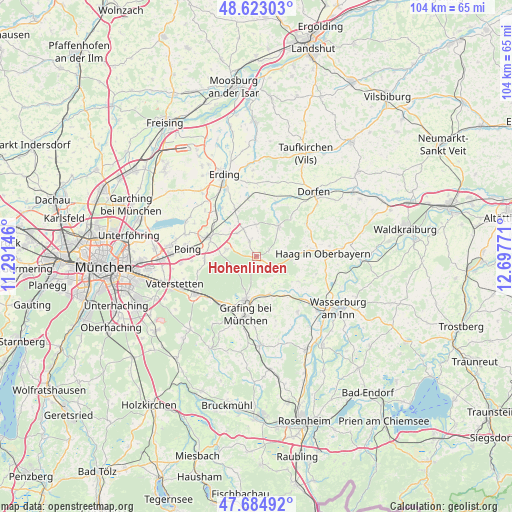
Hohenlinden GPS coordinates[2]
48° 9' 22.032" North, 11° 59' 40.488" East
| Map corner | latitude | longitude |
|---|---|---|
| Upper-left | 48.62303°, | 11.29146° |
| Center: | 48.15612°, | 11.99458° |
| Lower-right: | 47.68492°, | 12.69771° |
| Map W x H: | 104.3×104.3 km | = 64.8×64.8mi |
| max Lat: | 55.01917° ⇑93.3% North |
| Hohenlinden: | 48.15612° |
| min Lat: | ⇓6.7% South 47.40724° |
| min Long | Hohenlinden | max Long |
| 5.92978° | 11.99458° | 14.98853° |
| W 81.7%⇐ | ⇒18.3% E |
Elevation
Elevation of Hohenlinden is 542 m = 1778 ft, and this is 292.9 m = 961 ft above average elevation for this country.
| Max E: |
1256 m = 4121 ft | 8% |
| Hohenlinden | 542 m 1778 ft | |
| Avg. | 249.1 m = 817 ft | |
Min E: |
-5 m = -16 ft | 92% |
See also: Germany elevation on elevation.city.
Geographical zone
Hohenlinden is located in North temperate zone (between Tropic of Cancer and the Arctic Circle). Distance of this North polar circle is 2046.7 km =1271.8 mi to North.| Distance of | km | miles | from Hohenlinden |
|---|---|---|---|
| North Pole | 4652.6 | 2891 | to North |
| Arctic Circle | 2046.7 | 1271.8 | to North |
| Tropic Cancer | 2748.5 | 1707.8 | to South |
| Equator | 5354.5 | 3327.1 | to South |


Nearby cities:
15 places around Hohenlinden: (largest is in red/bold)
• Albaching
10 km =6.2 mi,  120°
120°
• Anzing
10.5 km =6.5 mi,  267°
267°
• Buch am Buchrain
6.6 km =4.1 mi,  0°
0°
• Ebersberg
9 km =5.6 mi,  191°
191°
• Forstern
3.3 km =2.1 mi,  336°
336°
• Forstinning
6.2 km =3.9 mi,  282°
282°
• Isen
7.7 km =4.8 mi,  36°
36°
• Lengdorf
12 km =7.5 mi,  19°
19°
• Maitenbeth
7.4 km =4.6 mi,  94°
94°
• Markt Schwaben
10 km =6.2 mi,  291°
291°
• Ottenhofen
10.6 km =6.6 mi,  309°
309°
• Pastetten
6.1 km =3.8 mi,  321°
321°
• Steinhöring
8.2 km =5.1 mi,  160°
160°
• Walpertskirchen
11.5 km =7.1 mi,  352°
352°
• Wörth
12.1 km =7.5 mi,  325°
325°
Sources, notices
• [Note1] Compared only with cities in Germany existing in our database
• [Src1] Map data: © OpenStreetMap contributors (CC-BY-SA)
• [Src2] Other city data from geonames.org with taken over terms of usage.
• [Src3] Geographical zone / Annual Mean Temperature by Robert A. Rohde @ Wikipedia
