Steinhöring geodata
Steinhöring (Bavaria) is a seat of a fourth-order administrative division; located in Germany in Europe/Berlin (GMT+2) time zone. With population of 3,759 people, there are 3435 cities with bigger population in this country. Compared to other cities in Germany, 94.3% of cities are located further ↑North; 82.2% of cities are located further ←West and 90.4% of cities have lower elevation than Steinhöring. Note1
Administrative division(s):
- Level 1: Bavaria
- Level 2: Upper Bavaria
- Level 3: Landkreis Ebersberg
- Level 4: Steinhöring


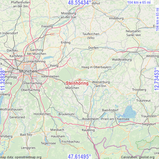
Steinhöring GPS coordinates[2]
48° 5' 12.444" North, 12° 1' 53.04" East
| Map corner | latitude | longitude |
|---|---|---|
| Upper-left | 48.55434°, | 11.32828° |
| Center: | 48.08679°, | 12.0314° |
| Lower-right: | 47.61495°, | 12.73453° |
| Map W x H: | 104.5×104.4 km | = 64.9×64.9mi |
| max Lat: | 55.01917° ⇑94.3% North |
| Steinhöring: | 48.08679° |
| min Lat: | ⇓5.7% South 47.40724° |
| min Long | Steinhöring | max Long |
| 5.92978° | 12.0314° | 14.98853° |
| W 82.2%⇐ | ⇒17.8% E |
Elevation
Elevation of Steinhöring is 518 m = 1699 ft, and this is 268.9 m = 882 ft above average elevation for this country.
| Max E: |
1256 m = 4121 ft | 9.6% |
| Steinhöring | 518 m 1699 ft | |
| Avg. | 249.1 m = 817 ft | |
Min E: |
-5 m = -16 ft | 90.4% |
See also: Germany elevation on elevation.city.
Geographical zone
Steinhöring is located in North temperate zone (between Tropic of Cancer and the Arctic Circle). Distance of this North polar circle is 2054.4 km =1276.5 mi to North.| Distance of | km | miles | from Steinhöring |
|---|---|---|---|
| North Pole | 4660.3 | 2895.8 | to North |
| Arctic Circle | 2054.4 | 1276.5 | to North |
| Tropic Cancer | 2740.8 | 1703.1 | to South |
| Equator | 5346.7 | 3322.3 | to South |


Nearby cities:
15 places around Steinhöring: (largest is in red/bold)
• Albaching
6.4 km =4 mi,  66°
66°
• Aßling
10.6 km =6.6 mi,  190°
190°
• Breitbrunn
10.3 km =6.4 mi,  117°
117°
• Ebersberg
4.6 km =2.9 mi,  256°
256°
• Edling
10.5 km =6.5 mi,  109°
109°
• Emmering
10.1 km =6.3 mi,  169°
169°
• Eschenlohe
7.7 km =4.8 mi,  180°
180°
• Fraueneuharting
5.5 km =3.4 mi, 167°
• Grafing bei München
6.5 km =4 mi,  226°
226°
• Hohenlinden
8.2 km =5.1 mi,  340°
340°
• Kirchseeon
10.7 km =6.6 mi, 260°
• Maitenbeth
8.4 km =5.2 mi,  32°
32°
• Pfaffing
6.8 km =4.2 mi, 121°
• Ramerberg
11.4 km =7.1 mi,  132°
132°
• Rechtmehring
10.6 km =6.6 mi, 71°
Sources, notices
• [Note1] Compared only with cities in Germany existing in our database
• [Src1] Map data: © OpenStreetMap contributors (CC-BY-SA)
• [Src2] Other city data from geonames.org with taken over terms of usage.
• [Src3] Geographical zone / Annual Mean Temperature by Robert A. Rohde @ Wikipedia
