Rimbach geodata
Rimbach (Hesse) is a seat of a fourth-order administrative division; located in Germany in Europe/Berlin (GMT+2) time zone. With population of 8,537 people, there are 1868 cities with bigger population in this country. Compared to other cities in Germany, 73.2% of cities are located further ↑North; 68.4% of cities are located further →East and 54.7% of cities have higher elevation than Rimbach. Note1
Administrative division(s):
- Level 1: Hesse
- Level 2: Regierungsbezirk Darmstadt
- Level 3: Landkreis Bergstraße
- Level 4: Rimbach


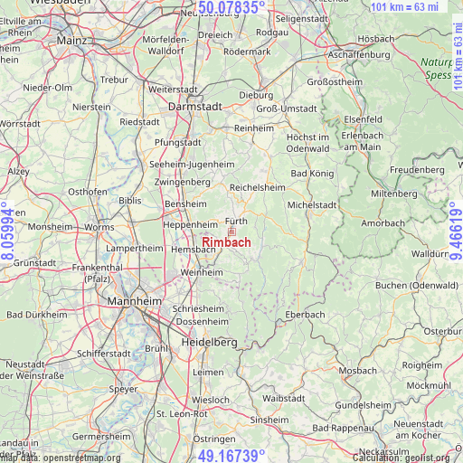
Rimbach GPS coordinates[2]
49° 37' 30" North, 8° 45' 47.016" East
| Map corner | latitude | longitude |
|---|---|---|
| Upper-left | 50.07835°, | 8.05994° |
| Center: | 49.625°, | 8.76306° |
| Lower-right: | 49.16739°, | 9.46619° |
| Map W x H: | 101.3×101.3 km | = 62.9×62.9mi |
| max Lat: | 55.01917° ⇑73.2% North |
| Rimbach: | 49.625° |
| min Lat: | ⇓26.8% South 47.40724° |
| min Long | Rimbach | max Long |
| 5.92978° | 8.76306° | 14.98853° |
| W 31.6%⇐ | ⇒68.4% E |
Elevation
Elevation of Rimbach is 191 m = 627 ft, and this is 58.1 m = 191 ft below average elevation for this country.
| Max E: |
1256 m = 4121 ft | 54.7% |
| Avg. | 249.1 m = 817 ft | |
| Rimbach | 191 m = 627 ft | |
Min E: |
-5 m = -16 ft | 45.3% |
See also: Germany elevation on elevation.city.
Geographical zone
Rimbach is located in North temperate zone (between Tropic of Cancer and the Arctic Circle). Distance of this North polar circle is 1883.4 km =1170.3 mi to North.| Distance of | km | miles | from Rimbach |
|---|---|---|---|
| North Pole | 4489.3 | 2789.5 | to North |
| Arctic Circle | 1883.4 | 1170.3 | to North |
| Tropic Cancer | 2911.9 | 1809.4 | to South |
| Equator | 5517.8 | 3428.6 | to South |


Nearby cities:
15 places around Rimbach: (largest is in red/bold)
• Bensheim
12.3 km =7.6 mi,  302°
302°
• Birkenau
8 km =5 mi,  210°
210°
• Fränkisch-Crumbach
15.1 km =9.4 mi,  27°
27°
• Fürth
3.3 km =2.1 mi, 28°
• Hemsbach
9.1 km =5.7 mi,  245°
245°
• Heppenheim an der Bergstrasse
9.6 km =6 mi,  280°
280°
• Laudenbach
8 km =5 mi,  260°
260°
• Lindenfels
6.7 km =4.2 mi,  11°
11°
• Lorsch
14.4 km =8.9 mi, 281°
• Lützelbach
13 km =8.1 mi,  1°
1°
• Mörlenbach
3.5 km =2.2 mi,  215°
215°
• Reichelsheim
11.1 km =6.9 mi, 29°
• Unter-Abtsteinach
11 km =6.8 mi,  171°
171°
• Wald-Michelbach
7.9 km =4.9 mi,  141°
141°
• Weinheim
10.9 km =6.8 mi, 219°
Sources, notices
• [Note1] Compared only with cities in Germany existing in our database
• [Src1] Map data: © OpenStreetMap contributors (CC-BY-SA)
• [Src2] Other city data from geonames.org with taken over terms of usage.
• [Src3] Geographical zone / Annual Mean Temperature by Robert A. Rohde @ Wikipedia
