Lindlar geodata
Lindlar (North Rhine-Westphalia) is a seat of a fourth-order administrative division; located in Germany in Europe/Berlin (GMT+2) time zone. With population of 22,723 people, there are 658 cities with bigger population in this country. Compared to other cities in Germany, 58.5% of cities are located further ↓South; 88.8% of cities are located further →East and 50.7% of cities have lower elevation than Lindlar. Note1
Administrative division(s):
- Level 1: North Rhine-Westphalia
- Level 2: Regierungsbezirk Köln
- Level 3: Oberbergischer Kreis
- Level 4: Lindlar


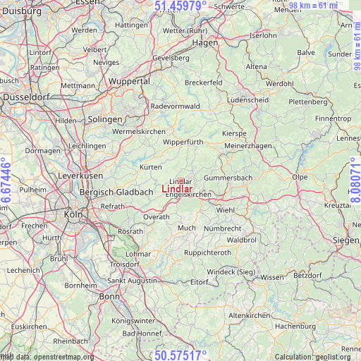
Lindlar GPS coordinates[2]
51° 1' 10.524" North, 7° 22' 39.288" East
| Map corner | latitude | longitude |
|---|---|---|
| Upper-left | 51.45979°, | 6.67446° |
| Center: | 51.01959°, | 7.37758° |
| Lower-right: | 50.57517°, | 8.08071° |
| Map W x H: | 98.4×98.4 km | = 61.1×61.1mi |
| max Lat: | 55.01917° ⇑41.5% North |
| Lindlar: | 51.01959° |
| min Lat: | ⇓58.5% South 47.40724° |
| min Long | Lindlar | max Long |
| 5.92978° | 7.37758° | 14.98853° |
| W 11.2%⇐ | ⇒88.8% E |
Elevation
Elevation of Lindlar is 231 m = 758 ft, and this is 18.1 m = 59 ft below average elevation for this country.
| Max E: |
1256 m = 4121 ft | 49.3% |
| Avg. | 249.1 m = 817 ft | |
| Lindlar | 231 m = 758 ft | |
Min E: |
-5 m = -16 ft | 50.7% |
See also: Germany elevation on elevation.city.
Geographical zone
Lindlar is located in North temperate zone (between Tropic of Cancer and the Arctic Circle). Distance of this North polar circle is 1728.3 km =1073.9 mi to North.| Distance of | km | miles | from Lindlar |
|---|---|---|---|
| North Pole | 4334.2 | 2693.1 | to North |
| Arctic Circle | 1728.3 | 1073.9 | to North |
| Tropic Cancer | 3066.9 | 1905.7 | to South |
| Equator | 5672.8 | 3524.9 | to South |


Nearby cities:
15 places around Lindlar: (largest is in red/bold)
• Bergisch Gladbach
17.5 km =10.9 mi,  257°
257°
• Bergneustadt
19.5 km =12.1 mi,  88°
88°
• Engelskirchen
4.3 km =2.7 mi,  143°
143°
• Gummersbach
13.1 km =8.1 mi, 86°
• Hückeswagen
14.7 km =9.1 mi,  350°
350°
• Kürten
8.5 km =5.3 mi,  293°
293°
• Marienheide
12.8 km =8 mi,  56°
56°
• Much
13 km =8.1 mi,  172°
172°
• Nümbrecht
17.2 km =10.7 mi, 138°
• Odenthal
18.3 km =11.4 mi,  274°
274°
• Overath
11.7 km =7.3 mi,  214°
214°
• Rösrath
19.4 km =12.1 mi,  224°
224°
• Wermelskirchen
17.5 km =10.9 mi,  319°
319°
• Wiehl
14.4 km =8.9 mi,  122°
122°
• Wipperfürth
10.8 km =6.7 mi,  7°
7°
Sources, notices
• [Note1] Compared only with cities in Germany existing in our database
• [Src1] Map data: © OpenStreetMap contributors (CC-BY-SA)
• [Src2] Other city data from geonames.org with taken over terms of usage.
• [Src3] Geographical zone / Annual Mean Temperature by Robert A. Rohde @ Wikipedia
