Overath geodata
Overath (North Rhine-Westphalia) is a populated place; located in Germany in Europe/Berlin (GMT+2) time zone. With population of 27,203 people, there are 527 cities with bigger population in this country. Compared to other cities in Germany, 56.8% of cities are located further ↓South; 90.1% of cities are located further →East and 69.2% of cities have higher elevation than Overath. Note1
Administrative division(s):
- Level 1: North Rhine-Westphalia
- Level 2: Regierungsbezirk Köln
- Level 3: Rheinisch-Bergischer Kreis
- Level 4: Overath


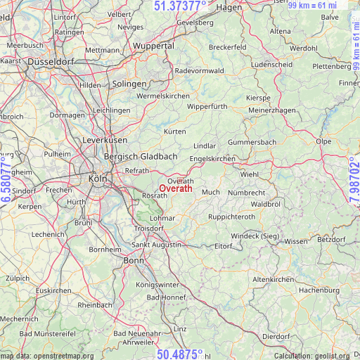
Overath GPS coordinates[2]
50° 55' 57.9" North, 7° 17' 2.004" East
| Map corner | latitude | longitude |
|---|---|---|
| Upper-left | 51.37377°, | 6.58077° |
| Center: | 50.93275°, | 7.28389° |
| Lower-right: | 50.4875°, | 7.98702° |
| Map W x H: | 98.5×98.5 km | = 61.2×61.2mi |
| max Lat: | 55.01917° ⇑43.2% North |
| Overath: | 50.93275° |
| min Lat: | ⇓56.8% South 47.40724° |
| min Long | Overath | max Long |
| 5.92978° | 7.28389° | 14.98853° |
| W 9.9%⇐ | ⇒90.1% E |
Elevation
Elevation of Overath is 96 m = 315 ft, and this is 153.1 m = 502 ft below average elevation for this country.
| Max E: |
1256 m = 4121 ft | 69.2% |
| Avg. | 249.1 m = 817 ft | |
| Overath | 96 m = 315 ft | |
Min E: |
-5 m = -16 ft | 30.8% |
See also: Germany elevation on elevation.city.
Geographical zone
Overath is located in North temperate zone (between Tropic of Cancer and the Arctic Circle). Distance of this North polar circle is 1738 km =1079.9 mi to North.| Distance of | km | miles | from Overath |
|---|---|---|---|
| North Pole | 4343.9 | 2699.2 | to North |
| Arctic Circle | 1738 | 1079.9 | to North |
| Tropic Cancer | 3057.3 | 1899.7 | to South |
| Equator | 5663.2 | 3518.9 | to South |


Nearby cities:
15 places around Overath: (largest is in red/bold)
• Bergisch Gladbach
12.1 km =7.5 mi,  299°
299°
• Eil
15 km =9.3 mi,  253°
253°
• Engelskirchen
11 km =6.8 mi,  55°
55°
• Gremberghoven
16 km =9.9 mi,  257°
257°
• Kürten
13.1 km =8.1 mi,  354°
354°
• Lindlar
11.7 km =7.3 mi,  34°
34°
• Lohmar
11.6 km =7.2 mi,  205°
205°
• Much
9 km =5.6 mi,  111°
111°
• Odenthal
16.2 km =10.1 mi,  313°
313°
• Porz am Rhein
16.6 km =10.3 mi, 251°
• Rath
13.4 km =8.3 mi,  265°
265°
• Rösrath
8.3 km =5.2 mi,  240°
240°
• Siegburg
15.7 km =9.8 mi,  199°
199°
• Troisdorf
16.7 km =10.4 mi, 214°
• Wahn-Heide
14.9 km =9.3 mi, 236°
Sources, notices
• [Note1] Compared only with cities in Germany existing in our database
• [Src1] Map data: © OpenStreetMap contributors (CC-BY-SA)
• [Src2] Other city data from geonames.org with taken over terms of usage.
• [Src3] Geographical zone / Annual Mean Temperature by Robert A. Rohde @ Wikipedia
