Limbach geodata
Limbach (Saxony) is a seat of a fourth-order administrative division; located in Germany in Europe/Berlin (GMT+2) time zone. With population of 1,574 people, there are 5736 cities with bigger population in this country. Compared to other cities in Germany, 51% of cities are located further ↑North; 85.2% of cities are located further ←West and 76.2% of cities have lower elevation than Limbach. Note1


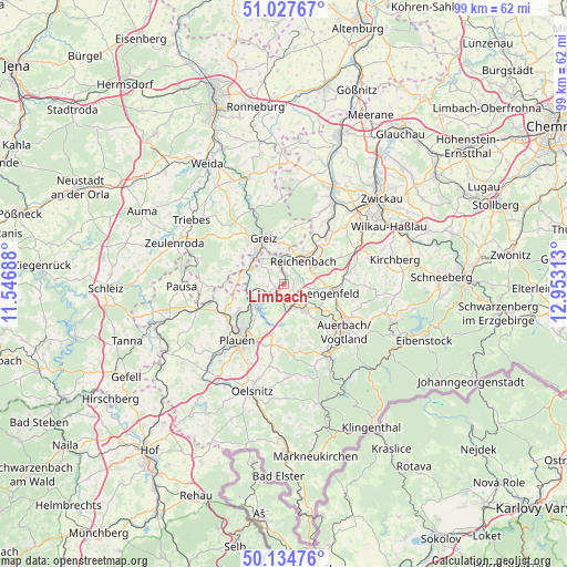
Limbach GPS coordinates[2]
50° 34' 59.988" North, 12° 15' 0" East
| Map corner | latitude | longitude |
|---|---|---|
| Upper-left | 51.02767°, | 11.54688° |
| Center: | 50.58333°, | 12.25° |
| Lower-right: | 50.13476°, | 12.95313° |
| Map W x H: | 99.3×99.3 km | = 61.7×61.7mi |
| max Lat: | 55.01917° ⇑51% North |
| Limbach: | 50.58333° |
| min Lat: | ⇓49% South 47.40724° |
| min Long | Limbach | max Long |
| 5.92978° | 12.25° | 14.98853° |
| W 85.2%⇐ | ⇒14.8% E |
Elevation
Elevation of Limbach is 407 m = 1335 ft, and this is 157.9 m = 518 ft above average elevation for this country.
| Max E: |
1256 m = 4121 ft | 23.8% |
| Limbach | 407 m 1335 ft | |
| Avg. | 249.1 m = 817 ft | |
Min E: |
-5 m = -16 ft | 76.2% |
See also: Germany elevation on elevation.city.
Geographical zone
Limbach is located in North temperate zone (between Tropic of Cancer and the Arctic Circle). Distance of this North polar circle is 1776.8 km =1104.1 mi to North.| Distance of | km | miles | from Limbach |
|---|---|---|---|
| North Pole | 4382.7 | 2723.3 | to North |
| Arctic Circle | 1776.8 | 1104.1 | to North |
| Tropic Cancer | 3018.4 | 1875.5 | to South |
| Equator | 5624.3 | 3494.8 | to South |


Nearby cities:
15 places around Limbach: (largest is in red/bold)
• Bergen
12.6 km =7.8 mi,  172°
172°
• Elsterberg
6.4 km =4 mi,  295°
295°
• Greiz
9 km =5.6 mi,  336°
336°
• Lengenfeld
8.2 km =5.1 mi,  100°
100°
• Mohlsdorf
9.7 km =6 mi,  6°
6°
• Mylau
4.1 km =2.5 mi,  15°
15°
• Netzschkau
3.5 km =2.2 mi,  352°
352°
• Neuensalz
9.6 km =6 mi,  194°
194°
• Neumark
11.4 km =7.1 mi,  41°
41°
• Plauen
12.4 km =7.7 mi,  219°
219°
• Pöhl
6 km =3.7 mi,  231°
231°
• Reichenbach/Vogtland
5.8 km =3.6 mi, 40°
• Reuth
4.4 km =2.7 mi,  327°
327°
• Treuen
5.9 km =3.7 mi,  140°
140°
• Waldkirchen
9.3 km =5.8 mi,  80°
80°
Sources, notices
• [Note1] Compared only with cities in Germany existing in our database
• [Src1] Map data: © OpenStreetMap contributors (CC-BY-SA)
• [Src2] Other city data from geonames.org with taken over terms of usage.
• [Src3] Geographical zone / Annual Mean Temperature by Robert A. Rohde @ Wikipedia
