Elsterberg geodata
Elsterberg (Saxony) is a populated place; located in Germany in Europe/Berlin (GMT+2) time zone. With population of 5,153 people, there are 2768 cities with bigger population in this country. Compared to other cities in Germany, 50.3% of cities are located further ↑North; 84.2% of cities are located further ←West and 60% of cities have lower elevation than Elsterberg. Note1


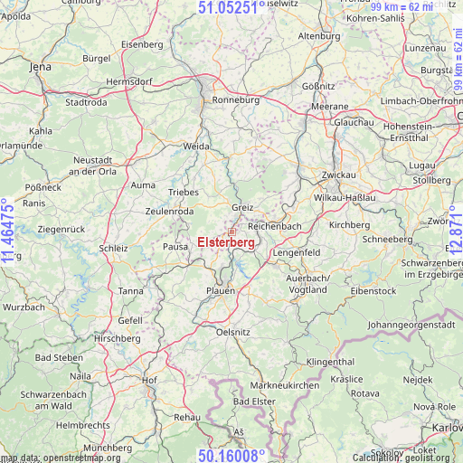
Elsterberg GPS coordinates[2]
50° 36' 30.276" North, 12° 10' 4.332" East
| Map corner | latitude | longitude |
|---|---|---|
| Upper-left | 51.05251°, | 11.46475° |
| Center: | 50.60841°, | 12.16787° |
| Lower-right: | 50.16008°, | 12.871° |
| Map W x H: | 99.2×99.2 km | = 61.6×61.6mi |
| max Lat: | 55.01917° ⇑50.3% North |
| Elsterberg: | 50.60841° |
| min Lat: | ⇓49.7% South 47.40724° |
| min Long | Elsterberg | max Long |
| 5.92978° | 12.16787° | 14.98853° |
| W 84.2%⇐ | ⇒15.8% E |
Elevation
Elevation of Elsterberg is 290 m = 951 ft, and this is 40.9 m = 134 ft above average elevation for this country.
| Max E: |
1256 m = 4121 ft | 40% |
| Elsterberg | 290 m 951 ft | |
| Avg. | 249.1 m = 817 ft | |
Min E: |
-5 m = -16 ft | 60% |
See also: Germany elevation on elevation.city.
Geographical zone
Elsterberg is located in North temperate zone (between Tropic of Cancer and the Arctic Circle). Distance of this North polar circle is 1774 km =1102.3 mi to North.| Distance of | km | miles | from Elsterberg |
|---|---|---|---|
| North Pole | 4379.9 | 2721.5 | to North |
| Arctic Circle | 1774 | 1102.3 | to North |
| Tropic Cancer | 3021.2 | 1877.3 | to South |
| Equator | 5627.1 | 3496.5 | to South |


Nearby cities:
15 places around Elsterberg: (largest is in red/bold)
• Greiz
5.9 km =3.7 mi,  21°
21°
• Kühdorf
11.7 km =7.3 mi,  339°
339°
• Langenwetzendorf
9.4 km =5.8 mi,  326°
326°
• Limbach
6.4 km =4 mi,  115°
115°
• Mehltheuer
11.6 km =7.2 mi,  232°
232°
• Mohlsdorf
9.7 km =6 mi,  45°
45°
• Mylau
7 km =4.3 mi,  80°
80°
• Netzschkau
5.4 km =3.4 mi, 83°
• Neugernsdorf
12.3 km =7.6 mi,  348°
348°
• Pausa
12.4 km =7.7 mi,  256°
256°
• Pöhl
6.6 km =4.1 mi,  170°
170°
• Reichenbach/Vogtland
9.7 km =6 mi, 80°
• Reuth
3.6 km =2.2 mi, 75°
• Syrau
9.6 km =6 mi,  220°
220°
• Treuen
12.1 km =7.5 mi,  127°
127°
Sources, notices
• [Note1] Compared only with cities in Germany existing in our database
• [Src1] Map data: © OpenStreetMap contributors (CC-BY-SA)
• [Src2] Other city data from geonames.org with taken over terms of usage.
• [Src3] Geographical zone / Annual Mean Temperature by Robert A. Rohde @ Wikipedia
