Reuth geodata
Reuth (Saxony) is a populated place; located in Germany in Europe/Berlin (GMT+2) time zone. With population of 1,083 people, there are 6897 cities with bigger population in this country. Compared to other cities in Germany, 50.2% of cities are located further ↑North; 84.8% of cities are located further ←West and 75.7% of cities have lower elevation than Reuth. Note1


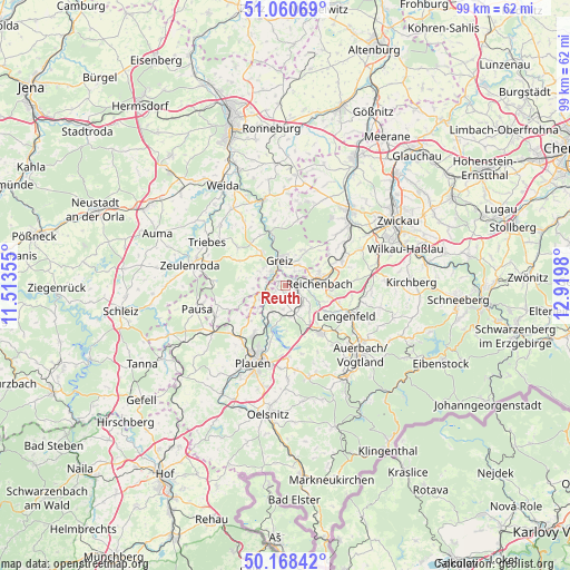
Reuth GPS coordinates[2]
50° 37' 0.012" North, 12° 13' 0.012" East
| Map corner | latitude | longitude |
|---|---|---|
| Upper-left | 51.06069°, | 11.51355° |
| Center: | 50.61667°, | 12.21667° |
| Lower-right: | 50.16842°, | 12.9198° |
| Map W x H: | 99.2×99.2 km | = 61.6×61.6mi |
| max Lat: | 55.01917° ⇑50.2% North |
| Reuth: | 50.61667° |
| min Lat: | ⇓49.8% South 47.40724° |
| min Long | Reuth | max Long |
| 5.92978° | 12.21667° | 14.98853° |
| W 84.8%⇐ | ⇒15.2% E |
Elevation
Elevation of Reuth is 403 m = 1322 ft, and this is 153.9 m = 505 ft above average elevation for this country.
| Max E: |
1256 m = 4121 ft | 24.3% |
| Reuth | 403 m 1322 ft | |
| Avg. | 249.1 m = 817 ft | |
Min E: |
-5 m = -16 ft | 75.7% |
See also: Germany elevation on elevation.city.
Geographical zone
Reuth is located in North temperate zone (between Tropic of Cancer and the Arctic Circle). Distance of this North polar circle is 1773.1 km =1101.8 mi to North.| Distance of | km | miles | from Reuth |
|---|---|---|---|
| North Pole | 4379 | 2721 | to North |
| Arctic Circle | 1773.1 | 1101.8 | to North |
| Tropic Cancer | 3022.1 | 1877.8 | to South |
| Equator | 5628 | 3497.1 | to South |


Nearby cities:
15 places around Reuth: (largest is in red/bold)
• Elsterberg
3.6 km =2.2 mi,  255°
255°
• Greiz
4.7 km =2.9 mi,  344°
344°
• Kühdorf
12.5 km =7.8 mi,  323°
323°
• Langenwetzendorf
11.1 km =6.9 mi,  308°
308°
• Lengenfeld
11.7 km =7.3 mi,  116°
116°
• Limbach
4.4 km =2.7 mi,  147°
147°
• Mohlsdorf
6.8 km =4.2 mi,  30°
30°
• Mylau
3.4 km =2.1 mi,  86°
86°
• Netzschkau
1.9 km =1.2 mi,  98°
98°
• Neumark
11 km =6.8 mi,  63°
63°
• Pöhl
7.8 km =4.8 mi,  197°
197°
• Reichenbach/Vogtland
6.2 km =3.9 mi,  83°
83°
• Teichwolframsdorf
11.8 km =7.3 mi,  10°
10°
• Treuen
10.3 km =6.4 mi,  143°
143°
• Waldkirchen
11.7 km =7.3 mi, 100°
Sources, notices
• [Note1] Compared only with cities in Germany existing in our database
• [Src1] Map data: © OpenStreetMap contributors (CC-BY-SA)
• [Src2] Other city data from geonames.org with taken over terms of usage.
• [Src3] Geographical zone / Annual Mean Temperature by Robert A. Rohde @ Wikipedia
