Greiz geodata
Greiz (Thuringia) is a seat of a third-order administrative division; located in Germany in Europe/Berlin (GMT+2) time zone. With population of 24,147 people, there are 620 cities with bigger population in this country. Compared to other cities in Germany, 50.9% of cities are located further ↓South; 84.6% of cities are located further ←West and 56.5% of cities have lower elevation than Greiz. Note1


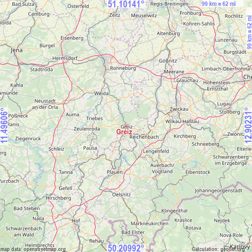
Greiz GPS coordinates[2]
50° 39' 28.008" North, 12° 11' 57.048" East
| Map corner | latitude | longitude |
|---|---|---|
| Upper-left | 51.10141°, | 11.49606° |
| Center: | 50.65778°, | 12.19918° |
| Lower-right: | 50.20992°, | 12.90231° |
| Map W x H: | 99.1×99.1 km | = 61.6×61.6mi |
| max Lat: | 55.01917° ⇑49.1% North |
| Greiz: | 50.65778° |
| min Lat: | ⇓50.9% South 47.40724° |
| min Long | Greiz | max Long |
| 5.92978° | 12.19918° | 14.98853° |
| W 84.6%⇐ | ⇒15.4% E |
Elevation
Elevation of Greiz is 269 m = 883 ft, and this is 19.9 m = 65 ft above average elevation for this country.
| Max E: |
1256 m = 4121 ft | 43.5% |
| Greiz | 269 m 883 ft | |
| Avg. | 249.1 m = 817 ft | |
Min E: |
-5 m = -16 ft | 56.5% |
See also: Germany elevation on elevation.city.
Geographical zone
Greiz is located in North temperate zone (between Tropic of Cancer and the Arctic Circle). Distance of this North polar circle is 1768.6 km =1099 mi to North.| Distance of | km | miles | from Greiz |
|---|---|---|---|
| North Pole | 4374.4 | 2718.1 | to North |
| Arctic Circle | 1768.6 | 1099 | to North |
| Tropic Cancer | 3026.7 | 1880.7 | to South |
| Equator | 5632.6 | 3499.9 | to South |


Nearby cities:
15 places around Greiz: (largest is in red/bold)
• Berga
10.7 km =6.6 mi,  346°
346°
• Elsterberg
5.9 km =3.7 mi,  201°
201°
• Hain
9.9 km =6.2 mi,  304°
304°
• Kühdorf
8.3 km =5.2 mi,  311°
311°
• Langenwetzendorf
7.8 km =4.8 mi,  287°
287°
• Limbach
9 km =5.6 mi,  156°
156°
• Lunzig
9.7 km =6 mi, 309°
• Mohlsdorf
4.8 km =3 mi,  74°
74°
• Mylau
6.4 km =4 mi,  133°
133°
• Netzschkau
5.8 km =3.6 mi,  147°
147°
• Neugernsdorf
8 km =5 mi,  324°
324°
• Reichenbach/Vogtland
8.3 km =5.2 mi,  117°
117°
• Reuth
4.7 km =2.9 mi, 164°
• Teichwolframsdorf
7.8 km =4.8 mi,  25°
25°
• Wildetaube
8.8 km =5.5 mi, 318°
Sources, notices
• [Note1] Compared only with cities in Germany existing in our database
• [Src1] Map data: © OpenStreetMap contributors (CC-BY-SA)
• [Src2] Other city data from geonames.org with taken over terms of usage.
• [Src3] Geographical zone / Annual Mean Temperature by Robert A. Rohde @ Wikipedia
