Liebstadt geodata
Liebstadt (Saxony) is a populated place; located in Germany in Europe/Berlin (GMT+2) time zone. With population of 1,367 people, there are 6147 cities with bigger population in this country. Compared to other cities in Germany, 55.4% of cities are located further ↓South; 97.4% of cities are located further ←West and 67.2% of cities have lower elevation than Liebstadt. Note1
Administrative division(s):
- Level 1: Saxony
- Level 3: Landkreis Sächsische Schweiz
- Level 4: Liebstadt


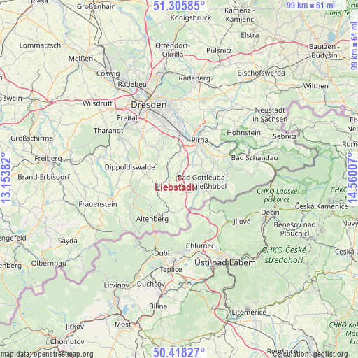
Liebstadt GPS coordinates[2]
50° 51' 51.012" North, 13° 51' 24.984" East
| Map corner | latitude | longitude |
|---|---|---|
| Upper-left | 51.30585°, | 13.15382° |
| Center: | 50.86417°, | 13.85694° |
| Lower-right: | 50.41827°, | 14.56007° |
| Map W x H: | 98.7×98.7 km | = 61.3×61.3mi |
| max Lat: | 55.01917° ⇑44.6% North |
| Liebstadt: | 50.86417° |
| min Lat: | ⇓55.4% South 47.40724° |
| min Long | Liebstadt | max Long |
| 5.92978° | 13.85694° | 14.98853° |
| W 97.4%⇐ | ⇒2.6% E |
Elevation
Elevation of Liebstadt is 337 m = 1106 ft, and this is 87.9 m = 288 ft above average elevation for this country.
| Max E: |
1256 m = 4121 ft | 32.8% |
| Liebstadt | 337 m 1106 ft | |
| Avg. | 249.1 m = 817 ft | |
Min E: |
-5 m = -16 ft | 67.2% |
See also: Germany elevation on elevation.city.
Geographical zone
Liebstadt is located in North temperate zone (between Tropic of Cancer and the Arctic Circle). Distance of this North polar circle is 1745.6 km =1084.7 mi to North.| Distance of | km | miles | from Liebstadt |
|---|---|---|---|
| North Pole | 4351.5 | 2703.9 | to North |
| Arctic Circle | 1745.6 | 1084.7 | to North |
| Tropic Cancer | 3049.6 | 1894.9 | to South |
| Equator | 5655.6 | 3514.2 | to South |


Nearby cities:
15 places around Liebstadt: (largest is in red/bold)
• Altenberg
13.2 km =8.2 mi,  213°
213°
• Bärenstein
8.1 km =5 mi, 210°
• Dippoldiswalde
13.7 km =8.5 mi,  285°
285°
• Dohma
7.9 km =4.9 mi,  42°
42°
• Dohna
10.2 km =6.3 mi,  0°
0°
• Geising
12.7 km =7.9 mi,  200°
200°
• Glashütte
5.6 km =3.5 mi,  255°
255°
• Heidenau
12 km =7.5 mi, 3°
• Hermsdorf
10.8 km =6.7 mi,  307°
307°
• Kreischa
11.5 km =7.1 mi,  321°
321°
• Pirna
11.9 km =7.4 mi,  28°
28°
• Reinhardtsgrimma
7.8 km =4.8 mi, 293°
• Schmiedeberg
13.1 km =8.1 mi, 256°
• Stadt Wehlen
16.1 km =10 mi,  49°
49°
• Struppen
13.6 km =8.5 mi,  55°
55°
Sources, notices
• [Note1] Compared only with cities in Germany existing in our database
• [Src1] Map data: © OpenStreetMap contributors (CC-BY-SA)
• [Src2] Other city data from geonames.org with taken over terms of usage.
• [Src3] Geographical zone / Annual Mean Temperature by Robert A. Rohde @ Wikipedia
