Heidenau geodata
Heidenau (Saxony) is a populated place; located in Germany in Europe/Berlin (GMT+2) time zone. With population of 16,756 people, there are 944 cities with bigger population in this country. Compared to other cities in Germany, 57.6% of cities are located further ↓South; 97.5% of cities are located further ←West and 65% of cities have higher elevation than Heidenau. Note1


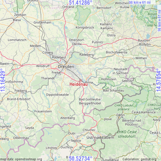
Heidenau GPS coordinates[2]
50° 58' 19.956" North, 13° 52' 2.676" East
| Map corner | latitude | longitude |
|---|---|---|
| Upper-left | 51.41286°, | 13.16429° |
| Center: | 50.97221°, | 13.86741° |
| Lower-right: | 50.52734°, | 14.57054° |
| Map W x H: | 98.5×98.5 km | = 61.2×61.2mi |
| max Lat: | 55.01917° ⇑42.4% North |
| Heidenau: | 50.97221° |
| min Lat: | ⇓57.6% South 47.40724° |
| min Long | Heidenau | max Long |
| 5.92978° | 13.86741° | 14.98853° |
| W 97.5%⇐ | ⇒2.5% E |
Elevation
Elevation of Heidenau is 120 m = 394 ft, and this is 129.1 m = 424 ft below average elevation for this country.
| Max E: |
1256 m = 4121 ft | 65% |
| Avg. | 249.1 m = 817 ft | |
| Heidenau | 120 m = 394 ft | |
Min E: |
-5 m = -16 ft | 35% |
See also: Germany elevation on elevation.city.
Geographical zone
Heidenau is located in North temperate zone (between Tropic of Cancer and the Arctic Circle). Distance of this North polar circle is 1733.6 km =1077.2 mi to North.| Distance of | km | miles | from Heidenau |
|---|---|---|---|
| North Pole | 4339.5 | 2696.4 | to North |
| Arctic Circle | 1733.6 | 1077.2 | to North |
| Tropic Cancer | 3061.7 | 1902.5 | to South |
| Equator | 5667.6 | 3521.7 | to South |


Nearby cities:
15 places around Heidenau: (largest is in red/bold)
• Albertstadt
14.2 km =8.8 mi,  330°
330°
• Bannewitz
10.8 km =6.7 mi,  282°
282°
• Dohma
7.7 km =4.8 mi,  143°
143°
• Dohna
1.9 km =1.2 mi,  199°
199°
• Dresden
12.6 km =7.8 mi,  314°
314°
• Dürrröhrsdorf
11.4 km =7.1 mi,  52°
52°
• Glashütte
14.7 km =9.1 mi, 204°
• Hermsdorf
10.8 km =6.7 mi,  239°
239°
• Kreischa
8.4 km =5.2 mi,  249°
249°
• Liebstadt
12 km =7.5 mi,  183°
183°
• Lohmen
9.6 km =6 mi,  79°
79°
• Pirna
5.1 km =3.2 mi,  107°
107°
• Reinhardtsgrimma
11.8 km =7.3 mi,  221°
221°
• Stadt Wehlen
11.6 km =7.2 mi,  97°
97°
• Struppen
11.3 km =7 mi, 112°
Sources, notices
• [Note1] Compared only with cities in Germany existing in our database
• [Src1] Map data: © OpenStreetMap contributors (CC-BY-SA)
• [Src2] Other city data from geonames.org with taken over terms of usage.
• [Src3] Geographical zone / Annual Mean Temperature by Robert A. Rohde @ Wikipedia
