Dohna geodata
Dohna (Saxony) is a populated place; located in Germany in Europe/Berlin (GMT+2) time zone. With population of 6,140 people, there are 2419 cities with bigger population in this country. Compared to other cities in Germany, 57.3% of cities are located further ↓South; 97.4% of cities are located further ←West and 58.5% of cities have higher elevation than Dohna. Note1


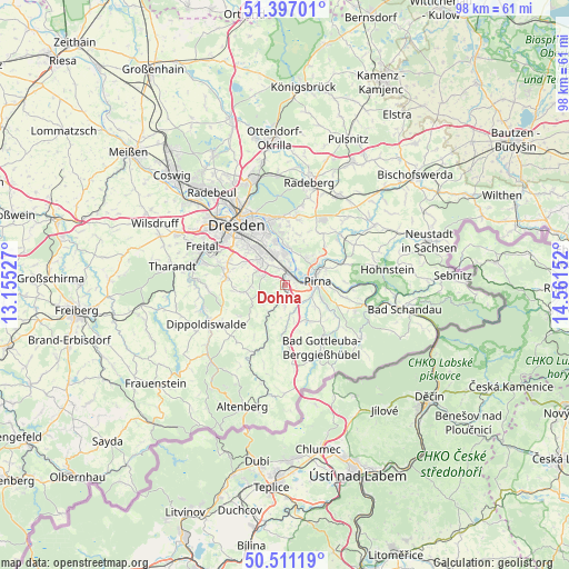
Dohna GPS coordinates[2]
50° 57' 22.356" North, 13° 51' 30.204" East
| Map corner | latitude | longitude |
|---|---|---|
| Upper-left | 51.39701°, | 13.15527° |
| Center: | 50.95621°, | 13.85839° |
| Lower-right: | 50.51119°, | 14.56152° |
| Map W x H: | 98.5×98.5 km | = 61.2×61.2mi |
| max Lat: | 55.01917° ⇑42.7% North |
| Dohna: | 50.95621° |
| min Lat: | ⇓57.3% South 47.40724° |
| min Long | Dohna | max Long |
| 5.92978° | 13.85839° | 14.98853° |
| W 97.4%⇐ | ⇒2.6% E |
Elevation
Elevation of Dohna is 164 m = 538 ft, and this is 85.1 m = 279 ft below average elevation for this country.
| Max E: |
1256 m = 4121 ft | 58.5% |
| Avg. | 249.1 m = 817 ft | |
| Dohna | 164 m = 538 ft | |
Min E: |
-5 m = -16 ft | 41.5% |
See also: Germany elevation on elevation.city.
Geographical zone
Dohna is located in North temperate zone (between Tropic of Cancer and the Arctic Circle). Distance of this North polar circle is 1735.4 km =1078.3 mi to North.| Distance of | km | miles | from Dohna |
|---|---|---|---|
| North Pole | 4341.3 | 2697.6 | to North |
| Arctic Circle | 1735.4 | 1078.3 | to North |
| Tropic Cancer | 3059.9 | 1901.3 | to South |
| Equator | 5665.8 | 3520.6 | to South |


Nearby cities:
15 places around Dohna: (largest is in red/bold)
• Bannewitz
10.7 km =6.6 mi,  292°
292°
• Dippoldiswalde
14.9 km =9.3 mi,  243°
243°
• Dohma
6.8 km =4.2 mi,  129°
129°
• Dresden
13.5 km =8.4 mi,  321°
321°
• Dürrröhrsdorf
13 km =8.1 mi,  48°
48°
• Glashütte
12.8 km =8 mi,  205°
205°
• Heidenau
1.9 km =1.2 mi,  19°
19°
• Hermsdorf
9.4 km =5.8 mi,  247°
247°
• Kreischa
7.3 km =4.5 mi,  260°
260°
• Liebstadt
10.2 km =6.3 mi,  180°
180°
• Lohmen
10.7 km =6.6 mi,  70°
70°
• Pirna
5.5 km =3.4 mi,  87°
87°
• Reinhardtsgrimma
10.1 km =6.3 mi,  225°
225°
• Stadt Wehlen
12.1 km =7.5 mi, 88°
• Struppen
11.4 km =7.1 mi,  102°
102°
Sources, notices
• [Note1] Compared only with cities in Germany existing in our database
• [Src1] Map data: © OpenStreetMap contributors (CC-BY-SA)
• [Src2] Other city data from geonames.org with taken over terms of usage.
• [Src3] Geographical zone / Annual Mean Temperature by Robert A. Rohde @ Wikipedia
