Pirna geodata
Pirna (Saxony) is a seat of a third-order administrative division; located in Germany in Europe/Berlin (GMT+2) time zone. With population of 40,322 people, there are 316 cities with bigger population in this country. Compared to other cities in Germany, 57.3% of cities are located further ↓South; 97.7% of cities are located further ←West and 65.2% of cities have higher elevation than Pirna. Note1


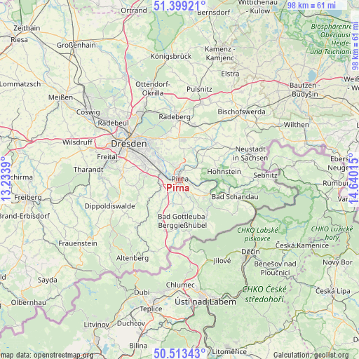
Pirna GPS coordinates[2]
50° 57' 30.348" North, 13° 56' 13.272" East
| Map corner | latitude | longitude |
|---|---|---|
| Upper-left | 51.39921°, | 13.2339° |
| Center: | 50.95843°, | 13.93702° |
| Lower-right: | 50.51343°, | 14.64015° |
| Map W x H: | 98.5×98.5 km | = 61.2×61.2mi |
| max Lat: | 55.01917° ⇑42.7% North |
| Pirna: | 50.95843° |
| min Lat: | ⇓57.3% South 47.40724° |
| min Long | Pirna | max Long |
| 5.92978° | 13.93702° | 14.98853° |
| W 97.7%⇐ | ⇒2.3% E |
Elevation
Elevation of Pirna is 119 m = 390 ft, and this is 130.1 m = 427 ft below average elevation for this country.
| Max E: |
1256 m = 4121 ft | 65.2% |
| Avg. | 249.1 m = 817 ft | |
| Pirna | 119 m = 390 ft | |
Min E: |
-5 m = -16 ft | 34.8% |
See also: Pirna elevation on elevation.city.
Geographical zone
Pirna is located in North temperate zone (between Tropic of Cancer and the Arctic Circle). Distance of this North polar circle is 1735.1 km =1078.1 mi to North.| Distance of | km | miles | from Pirna |
|---|---|---|---|
| North Pole | 4341 | 2697.4 | to North |
| Arctic Circle | 1735.1 | 1078.1 | to North |
| Tropic Cancer | 3060.1 | 1901.5 | to South |
| Equator | 5666 | 3520.7 | to South |


Nearby cities:
15 places around Pirna: (largest is in red/bold)
• Dohma
4.7 km =2.9 mi,  183°
183°
• Dohna
5.5 km =3.4 mi,  267°
267°
• Dürrröhrsdorf
9.4 km =5.8 mi,  26°
26°
• Heidenau
5.1 km =3.2 mi,  287°
287°
• Hohnstein
12.6 km =7.8 mi,  79°
79°
• Kreischa
12.8 km =8 mi,  263°
263°
• Kurort Gohrisch
13 km =8.1 mi,  113°
113°
• Königstein
10.6 km =6.6 mi,  116°
116°
• Liebstadt
11.9 km =7.4 mi,  208°
208°
• Lohmen
5.7 km =3.5 mi,  54°
54°
• Porschdorf
13.4 km =8.3 mi,  97°
97°
• Rathmannsdorf
14.7 km =9.1 mi, 102°
• Stadt Wehlen
6.6 km =4.1 mi,  90°
90°
• Stolpen
14.2 km =8.8 mi,  44°
44°
• Struppen
6.2 km =3.9 mi, 116°
Sources, notices
• [Note1] Compared only with cities in Germany existing in our database
• [Src1] Map data: © OpenStreetMap contributors (CC-BY-SA)
• [Src2] Other city data from geonames.org with taken over terms of usage.
• [Src3] Geographical zone / Annual Mean Temperature by Robert A. Rohde @ Wikipedia
