Lichtentanne geodata
Lichtentanne (Saxony) is a seat of a fourth-order administrative division; located in Germany in Europe/Berlin (GMT+2) time zone. With population of 7,163 people, there are 2150 cities with bigger population in this country. Compared to other cities in Germany, 51.8% of cities are located further ↓South; 87.3% of cities are located further ←West and 65.5% of cities have lower elevation than Lichtentanne. Note1


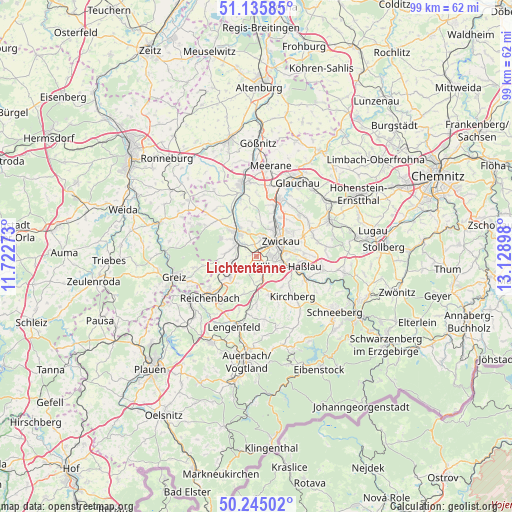
Lichtentanne GPS coordinates[2]
50° 41' 33.18" North, 12° 25' 33.06" East
| Map corner | latitude | longitude |
|---|---|---|
| Upper-left | 51.13585°, | 11.72273° |
| Center: | 50.69255°, | 12.42585° |
| Lower-right: | 50.24502°, | 13.12898° |
| Map W x H: | 99.1×99 km | = 61.6×61.5mi |
| max Lat: | 55.01917° ⇑48.2% North |
| Lichtentanne: | 50.69255° |
| min Lat: | ⇓51.8% South 47.40724° |
| min Long | Lichtentanne | max Long |
| 5.92978° | 12.42585° | 14.98853° |
| W 87.3%⇐ | ⇒12.7% E |
Elevation
Elevation of Lichtentanne is 325 m = 1066 ft, and this is 75.9 m = 249 ft above average elevation for this country.
| Max E: |
1256 m = 4121 ft | 34.5% |
| Lichtentanne | 325 m 1066 ft | |
| Avg. | 249.1 m = 817 ft | |
Min E: |
-5 m = -16 ft | 65.5% |
See also: Germany elevation on elevation.city.
Geographical zone
Lichtentanne is located in North temperate zone (between Tropic of Cancer and the Arctic Circle). Distance of this North polar circle is 1764.7 km =1096.5 mi to North.| Distance of | km | miles | from Lichtentanne |
|---|---|---|---|
| North Pole | 4370.6 | 2715.8 | to North |
| Arctic Circle | 1764.7 | 1096.5 | to North |
| Tropic Cancer | 3030.6 | 1883.1 | to South |
| Equator | 5636.5 | 3502.4 | to South |


Nearby cities:
15 places around Lichtentanne: (largest is in red/bold)
• Fraureuth
5.4 km =3.4 mi,  278°
278°
• Hartmannsdorf
7.3 km =4.5 mi,  0°
0°
• Hirschfeld
7.9 km =4.9 mi,  163°
163°
• Kirchberg
10.5 km =6.5 mi,  138°
138°
• Langenbernsdorf
9.9 km =6.2 mi,  315°
315°
• Leubnitz
5.9 km =3.7 mi,  304°
304°
• Mohlsdorf
11.6 km =7.2 mi,  257°
257°
• Neumark
6.1 km =3.8 mi,  233°
233°
• Reichenbach/Vogtland
11.6 km =7.2 mi, 228°
• Reinsdorf
9.2 km =5.7 mi,  86°
86°
• Waldkirchen
11.1 km =6.9 mi,  196°
196°
• Weißenborn
6.1 km =3.8 mi,  31°
31°
• Werdau
6 km =3.7 mi, 323°
• Wilkau-Haßlau
6.6 km =4.1 mi,  107°
107°
• Zwickau
5.9 km =3.7 mi,  48°
48°
Sources, notices
• [Note1] Compared only with cities in Germany existing in our database
• [Src1] Map data: © OpenStreetMap contributors (CC-BY-SA)
• [Src2] Other city data from geonames.org with taken over terms of usage.
• [Src3] Geographical zone / Annual Mean Temperature by Robert A. Rohde @ Wikipedia
