Weißenborn geodata
Weißenborn (Saxony) is a section of populated place; located in Germany in Europe/Berlin (GMT+2) time zone. With population of 2,747 people, there are 4198 cities with bigger population in this country. Compared to other cities in Germany, 53.1% of cities are located further ↓South; 87.8% of cities are located further ←West and 59.8% of cities have lower elevation than Weißenborn. Note1


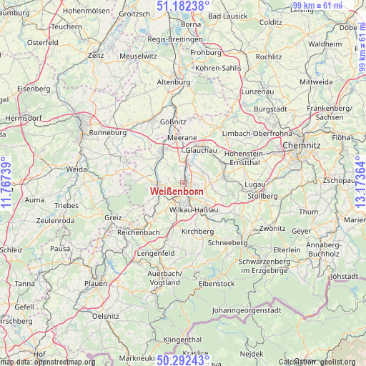
Weißenborn GPS coordinates[2]
50° 44' 22.272" North, 12° 28' 13.836" East
| Map corner | latitude | longitude |
|---|---|---|
| Upper-left | 51.18238°, | 11.76739° |
| Center: | 50.73952°, | 12.47051° |
| Lower-right: | 50.29243°, | 13.17364° |
| Map W x H: | 99×99 km | = 61.5×61.5mi |
| max Lat: | 55.01917° ⇑46.9% North |
| Weißenborn: | 50.73952° |
| min Lat: | ⇓53.1% South 47.40724° |
| min Long | Weißenborn | max Long |
| 5.92978° | 12.47051° | 14.98853° |
| W 87.8%⇐ | ⇒12.2% E |
Elevation
Elevation of Weißenborn is 289 m = 948 ft, and this is 39.9 m = 131 ft above average elevation for this country.
| Max E: |
1256 m = 4121 ft | 40.2% |
| Weißenborn | 289 m 948 ft | |
| Avg. | 249.1 m = 817 ft | |
Min E: |
-5 m = -16 ft | 59.8% |
See also: Germany elevation on elevation.city.
Geographical zone
Weißenborn is located in North temperate zone (between Tropic of Cancer and the Arctic Circle). Distance of this North polar circle is 1759.5 km =1093.3 mi to North.| Distance of | km | miles | from Weißenborn |
|---|---|---|---|
| North Pole | 4365.4 | 2712.5 | to North |
| Arctic Circle | 1759.5 | 1093.3 | to North |
| Tropic Cancer | 3035.8 | 1886.4 | to South |
| Equator | 5641.7 | 3505.6 | to South |


Nearby cities:
15 places around Weißenborn: (largest is in red/bold)
• Crimmitschau
10.2 km =6.3 mi,  326°
326°
• Dennheritz
8.3 km =5.2 mi,  357°
357°
• Fraureuth
9.6 km =6 mi,  242°
242°
• Glauchau
10.4 km =6.5 mi,  30°
30°
• Hartmannsdorf
3.7 km =2.3 mi,  303°
303°
• Langenbernsdorf
10.3 km =6.4 mi,  280°
280°
• Leubnitz
8.2 km =5.1 mi,  257°
257°
• Lichtenstein
11.4 km =7.1 mi,  80°
80°
• Lichtentanne
6.1 km =3.8 mi,  211°
211°
• Mülsen
6.9 km =4.3 mi, 80°
• Neukirchen
9.2 km =5.7 mi,  318°
318°
• Reinsdorf
7.6 km =4.7 mi,  127°
127°
• Werdau
6.7 km =4.2 mi,  266°
266°
• Wilkau-Haßlau
7.8 km =4.8 mi,  156°
156°
• Zwickau
1.9 km =1.2 mi,  137°
137°
Sources, notices
• [Note1] Compared only with cities in Germany existing in our database
• [Src1] Map data: © OpenStreetMap contributors (CC-BY-SA)
• [Src2] Other city data from geonames.org with taken over terms of usage.
• [Src3] Geographical zone / Annual Mean Temperature by Robert A. Rohde @ Wikipedia
