Glandorf geodata
Glandorf (Lower Saxony) is a seat of a fourth-order administrative division; located in Germany in Europe/Berlin (GMT+2) time zone. With population of 6,867 people, there are 2212 cities with bigger population in this country. Compared to other cities in Germany, 72.9% of cities are located further ↓South; 77.2% of cities are located further →East and 73% of cities have higher elevation than Glandorf. Note1


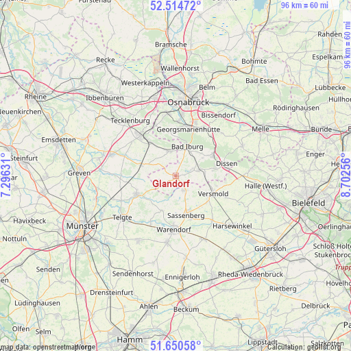
Glandorf GPS coordinates[2]
52° 5' 5.064" North, 7° 59' 57.984" East
| Map corner | latitude | longitude |
|---|---|---|
| Upper-left | 52.51472°, | 7.29631° |
| Center: | 52.08474°, | 7.99944° |
| Lower-right: | 51.65058°, | 8.70256° |
| Map W x H: | 96.1×96.1 km | = 59.7×59.7mi |
| max Lat: | 55.01917° ⇑27.1% North |
| Glandorf: | 52.08474° |
| min Lat: | ⇓72.9% South 47.40724° |
| min Long | Glandorf | max Long |
| 5.92978° | 7.99944° | 14.98853° |
| W 22.8%⇐ | ⇒77.2% E |
Elevation
Elevation of Glandorf is 72 m = 236 ft, and this is 177.1 m = 581 ft below average elevation for this country.
| Max E: |
1256 m = 4121 ft | 73% |
| Avg. | 249.1 m = 817 ft | |
| Glandorf | 72 m = 236 ft | |
Min E: |
-5 m = -16 ft | 27% |
See also: Germany elevation on elevation.city.
Geographical zone
Glandorf is located in North temperate zone (between Tropic of Cancer and the Arctic Circle). Distance of this North polar circle is 1609.9 km =1000.3 mi to North.| Distance of | km | miles | from Glandorf |
|---|---|---|---|
| North Pole | 4215.8 | 2619.6 | to North |
| Arctic Circle | 1609.9 | 1000.3 | to North |
| Tropic Cancer | 3185.4 | 1979.3 | to South |
| Equator | 5791.3 | 3598.5 | to South |


Nearby cities:
15 places around Glandorf: (largest is in red/bold)
• Bad Iburg
8.3 km =5.2 mi,  20°
20°
• Bad Laer
6 km =3.7 mi,  73°
73°
• Bad Rothenfelde
12 km =7.5 mi, 72°
• Dissen
14.1 km =8.8 mi,  75°
75°
• Georgsmarienhütte
13.5 km =8.4 mi,  13°
13°
• Hagen
12.5 km =7.8 mi,  354°
354°
• Hasbergen
17.2 km =10.7 mi, 351°
• Hilter
11.6 km =7.2 mi,  60°
60°
• Ladbergen
17.9 km =11.1 mi,  287°
287°
• Lengerich
14.8 km =9.2 mi,  320°
320°
• Lienen
7.3 km =4.5 mi, 351°
• Ostbevern
11.8 km =7.3 mi,  245°
245°
• Sassenberg
10.7 km =6.6 mi,  164°
164°
• Versmold
11.6 km =7.2 mi,  115°
115°
• Warendorf
14.9 km =9.3 mi,  183°
183°
Sources, notices
• [Note1] Compared only with cities in Germany existing in our database
• [Src1] Map data: © OpenStreetMap contributors (CC-BY-SA)
• [Src2] Other city data from geonames.org with taken over terms of usage.
• [Src3] Geographical zone / Annual Mean Temperature by Robert A. Rohde @ Wikipedia
