Augustdorf geodata
Augustdorf (North Rhine-Westphalia) is a seat of a fourth-order administrative division; located in Germany in Europe/Berlin (GMT+2) time zone. With population of 9,889 people, there are 1647 cities with bigger population in this country. Compared to other cities in Germany, 71.2% of cities are located further ↓South; 68.8% of cities are located further →East and 57.8% of cities have higher elevation than Augustdorf. Note1
Administrative division(s):
- Level 1: North Rhine-Westphalia
- Level 2: Regierungsbezirk Detmold
- Level 3: Kreis Lippe
- Level 4: Augustdorf


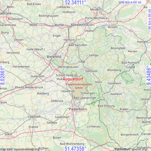
Augustdorf GPS coordinates[2]
51° 54' 33.984" North, 8° 43' 54.228" East
| Map corner | latitude | longitude |
|---|---|---|
| Upper-left | 52.34111°, | 8.02861° |
| Center: | 51.90944°, | 8.73173° |
| Lower-right: | 51.47358°, | 9.43486° |
| Map W x H: | 96.5×96.5 km | = 60×60mi |
| max Lat: | 55.01917° ⇑28.8% North |
| Augustdorf: | 51.90944° |
| min Lat: | ⇓71.2% South 47.40724° |
| min Long | Augustdorf | max Long |
| 5.92978° | 8.73173° | 14.98853° |
| W 31.2%⇐ | ⇒68.8% E |
Elevation
Elevation of Augustdorf is 169 m = 554 ft, and this is 80.1 m = 263 ft below average elevation for this country.
| Max E: |
1256 m = 4121 ft | 57.8% |
| Avg. | 249.1 m = 817 ft | |
| Augustdorf | 169 m = 554 ft | |
Min E: |
-5 m = -16 ft | 42.2% |
See also: Germany elevation on elevation.city.
Geographical zone
Augustdorf is located in North temperate zone (between Tropic of Cancer and the Arctic Circle). Distance of this North polar circle is 1629.4 km =1012.5 mi to North.| Distance of | km | miles | from Augustdorf |
|---|---|---|---|
| North Pole | 4235.3 | 2631.7 | to North |
| Arctic Circle | 1629.4 | 1012.5 | to North |
| Tropic Cancer | 3165.9 | 1967.2 | to South |
| Equator | 5771.8 | 3586.4 | to South |


Nearby cities:
15 places around Augustdorf: (largest is in red/bold)
• Bad Lippspringe
15.2 km =9.4 mi,  157°
157°
• Bad Meinberg
17.3 km =10.7 mi,  94°
94°
• Bad Salzuflen
19.7 km =12.2 mi,  2°
2°
• Bielefeld
19.4 km =12.1 mi,  315°
315°
• Delbrück
19.8 km =12.3 mi,  215°
215°
• Detmold
10.2 km =6.3 mi,  71°
71°
• Horn
15.2 km =9.4 mi,  106°
106°
• Horn-Bad Meinberg
16.1 km =10 mi,  99°
99°
• Hövelhof
11.7 km =7.3 mi,  208°
208°
• Lage
10.1 km =6.3 mi,  24°
24°
• Lemgo
17.5 km =10.9 mi,  41°
41°
• Leopoldshöhe
11.7 km =7.3 mi,  348°
348°
• Oerlinghausen
6.9 km =4.3 mi, 316°
• Schlangen
13.6 km =8.5 mi,  144°
144°
• Verl
15 km =9.3 mi,  258°
258°
Sources, notices
• [Note1] Compared only with cities in Germany existing in our database
• [Src1] Map data: © OpenStreetMap contributors (CC-BY-SA)
• [Src2] Other city data from geonames.org with taken over terms of usage.
• [Src3] Geographical zone / Annual Mean Temperature by Robert A. Rohde @ Wikipedia
