Horn geodata
Horn (North Rhine-Westphalia) is a section of populated place; located in Germany in Europe/Berlin (GMT+2) time zone. With population of 7,018 people, there are 2180 cities with bigger population in this country. Compared to other cities in Germany, 70.8% of cities are located further ↓South; 66.1% of cities are located further →East and 50.7% of cities have higher elevation than Horn. Note1
Administrative division(s):
- Level 1: North Rhine-Westphalia
- Level 2: Regierungsbezirk Detmold
- Level 3: Kreis Lippe
- Level 4: Horn-Bad Meinberg


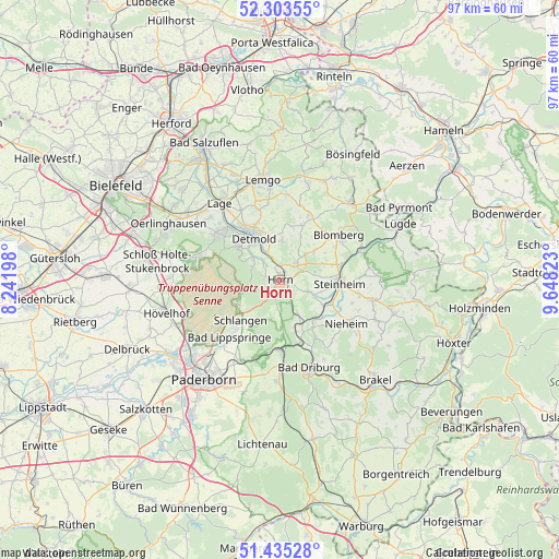
Horn GPS coordinates[2]
51° 52' 17.436" North, 8° 56' 42.36" East
| Map corner | latitude | longitude |
|---|---|---|
| Upper-left | 52.30355°, | 8.24198° |
| Center: | 51.87151°, | 8.9451° |
| Lower-right: | 51.43528°, | 9.64823° |
| Map W x H: | 96.5×96.5 km | = 60×60mi |
| max Lat: | 55.01917° ⇑29.2% North |
| Horn: | 51.87151° |
| min Lat: | ⇓70.8% South 47.40724° |
| min Long | Horn | max Long |
| 5.92978° | 8.9451° | 14.98853° |
| W 33.9%⇐ | ⇒66.1% E |
Elevation
Elevation of Horn is 220 m = 722 ft, and this is 29.1 m = 95 ft below average elevation for this country.
| Max E: |
1256 m = 4121 ft | 50.7% |
| Avg. | 249.1 m = 817 ft | |
| Horn | 220 m = 722 ft | |
Min E: |
-5 m = -16 ft | 49.3% |
See also: Germany elevation on elevation.city.
Geographical zone
Horn is located in North temperate zone (between Tropic of Cancer and the Arctic Circle). Distance of this North polar circle is 1633.6 km =1015.1 mi to North.| Distance of | km | miles | from Horn |
|---|---|---|---|
| North Pole | 4239.5 | 2634.3 | to North |
| Arctic Circle | 1633.6 | 1015.1 | to North |
| Tropic Cancer | 3161.7 | 1964.6 | to South |
| Equator | 5767.6 | 3583.8 | to South |


Nearby cities:
15 places around Horn: (largest is in red/bold)
• Altenbeken
11.9 km =7.4 mi,  181°
181°
• Augustdorf
15.2 km =9.4 mi,  286°
286°
• Bad Driburg
16.2 km =10.1 mi,  161°
161°
• Bad Lippspringe
13.2 km =8.2 mi,  221°
221°
• Bad Meinberg
3.8 km =2.4 mi,  43°
43°
• Barntrup
17.7 km =11 mi, 41°
• Blomberg
12.8 km =8 mi,  51°
51°
• Detmold
8.9 km =5.5 mi,  326°
326°
• Horn-Bad Meinberg
2 km =1.2 mi, 37°
• Lage
17 km =10.6 mi,  322°
322°
• Lemgo
17.7 km =11 mi,  349°
349°
• Nieheim
13.7 km =8.5 mi,  122°
122°
• Schieder-Schwalenberg
17.2 km =10.7 mi,  87°
87°
• Schlangen
9.7 km =6 mi, 224°
• Steinheim
10 km =6.2 mi, 90°
Sources, notices
• [Note1] Compared only with cities in Germany existing in our database
• [Src1] Map data: © OpenStreetMap contributors (CC-BY-SA)
• [Src2] Other city data from geonames.org with taken over terms of usage.
• [Src3] Geographical zone / Annual Mean Temperature by Robert A. Rohde @ Wikipedia
