Detmold geodata
Detmold (North Rhine-Westphalia) is a seat of a second-order administrative division; located in Germany in Europe/Berlin (GMT+2) time zone. With population of 73,680 people, there are 143 cities with bigger population in this country. Compared to other cities in Germany, 71.5% of cities are located further ↓South; 67% of cities are located further →East and 62.5% of cities have higher elevation than Detmold. Note1
Administrative division(s):
- Level 1: North Rhine-Westphalia
- Level 2: Regierungsbezirk Detmold
- Level 3: Kreis Lippe
- Level 4: Detmold


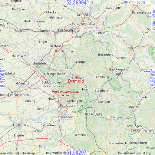
Detmold GPS coordinates[2]
51° 56' 18.78" North, 8° 52' 23.448" East
| Map corner | latitude | longitude |
|---|---|---|
| Upper-left | 52.36994°, | 8.17005° |
| Center: | 51.93855°, | 8.87318° |
| Lower-right: | 51.50297°, | 9.5763° |
| Map W x H: | 96.4×96.4 km | = 59.9×59.9mi |
| max Lat: | 55.01917° ⇑28.5% North |
| Detmold: | 51.93855° |
| min Lat: | ⇓71.5% South 47.40724° |
| min Long | Detmold | max Long |
| 5.92978° | 8.87318° | 14.98853° |
| W 33%⇐ | ⇒67% E |
Elevation
Elevation of Detmold is 135 m = 443 ft, and this is 114.1 m = 374 ft below average elevation for this country.
| Max E: |
1256 m = 4121 ft | 62.5% |
| Avg. | 249.1 m = 817 ft | |
| Detmold | 135 m = 443 ft | |
Min E: |
-5 m = -16 ft | 37.5% |
See also: Detmold elevation on elevation.city.
Geographical zone
Detmold is located in North temperate zone (between Tropic of Cancer and the Arctic Circle). Distance of this North polar circle is 1626.1 km =1010.4 mi to North.| Distance of | km | miles | from Detmold |
|---|---|---|---|
| North Pole | 4232 | 2629.6 | to North |
| Arctic Circle | 1626.1 | 1010.4 | to North |
| Tropic Cancer | 3169.1 | 1969.2 | to South |
| Equator | 5775 | 3588.4 | to South |


Nearby cities:
15 places around Detmold: (largest is in red/bold)
• Augustdorf
10.2 km =6.3 mi,  251°
251°
• Bad Lippspringe
17.7 km =11 mi,  192°
192°
• Bad Meinberg
8.9 km =5.5 mi,  122°
122°
• Bad Salzuflen
18.6 km =11.6 mi,  331°
331°
• Barntrup
17.6 km =10.9 mi,  70°
70°
• Blomberg
14.9 km =9.3 mi,  87°
87°
• Dörentrup
14.4 km =8.9 mi,  37°
37°
• Horn
8.9 km =5.5 mi,  146°
146°
• Horn-Bad Meinberg
8.5 km =5.3 mi,  133°
133°
• Lage
8.1 km =5 mi,  317°
317°
• Lemgo
10.1 km =6.3 mi,  10°
10°
• Leopoldshöhe
14.5 km =9 mi,  304°
304°
• Oerlinghausen
14.6 km =9.1 mi,  277°
277°
• Schlangen
14.4 km =8.9 mi, 187°
• Steinheim
16.8 km =10.4 mi, 116°
Sources, notices
• [Note1] Compared only with cities in Germany existing in our database
• [Src1] Map data: © OpenStreetMap contributors (CC-BY-SA)
• [Src2] Other city data from geonames.org with taken over terms of usage.
• [Src3] Geographical zone / Annual Mean Temperature by Robert A. Rohde @ Wikipedia
