Leer geodata
Leer (Lower Saxony) is a seat of a third-order administrative division; located in Germany in Europe/Berlin (GMT+2) time zone. With population of 33,886 people, there are 399 cities with bigger population in this country. Compared to other cities in Germany, 83.1% of cities are located further ↓South; 87.7% of cities are located further →East and 95.6% of cities have higher elevation than Leer. Note1
Administrative division(s):
- Level 1: Lower Saxony
- Level 3: Landkreis Leer
- Level 4: Leer (Ostfriesland)


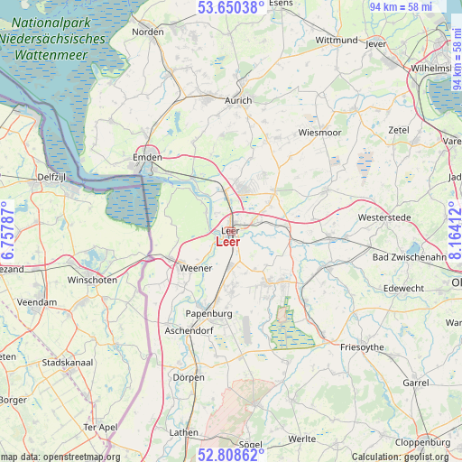
Leer GPS coordinates[2]
53° 13' 53.652" North, 7° 27' 39.6" East
| Map corner | latitude | longitude |
|---|---|---|
| Upper-left | 53.65038°, | 6.75787° |
| Center: | 53.23157°, | 7.461° |
| Lower-right: | 52.80862°, | 8.16412° |
| Map W x H: | 93.6×93.6 km | = 58.2×58.2mi |
| max Lat: | 55.01917° ⇑16.9% North |
| Leer: | 53.23157° |
| min Lat: | ⇓83.1% South 47.40724° |
| min Long | Leer | max Long |
| 5.92978° | 7.461° | 14.98853° |
| W 12.3%⇐ | ⇒87.7% E |
Elevation
Elevation of Leer is 7 m = 23 ft, and this is 242.1 m = 794 ft below average elevation for this country.
| Max E: |
1256 m = 4121 ft | 95.6% |
| Avg. | 249.1 m = 817 ft | |
| Leer | 7 m = 23 ft | |
Min E: |
-5 m = -16 ft | 4.4% |
See also: Germany elevation on elevation.city.
Geographical zone
Leer is located in North temperate zone (between Tropic of Cancer and the Arctic Circle). Distance of this North polar circle is 1482.4 km =921.1 mi to North.| Distance of | km | miles | from Leer |
|---|---|---|---|
| North Pole | 4088.3 | 2540.4 | to North |
| Arctic Circle | 1482.4 | 921.1 | to North |
| Tropic Cancer | 3312.9 | 2058.5 | to South |
| Equator | 5918.8 | 3677.8 | to South |


Nearby cities:
15 places around Leer: (largest is in red/bold)
• Brinkum
8 km =5 mi,  60°
60°
• Bunde
14 km =8.7 mi,  247°
247°
• Detern
14.4 km =8.9 mi,  99°
99°
• Filsum
11.2 km =7 mi,  83°
83°
• Firrel
17.7 km =11 mi,  50°
50°
• Hesel
12 km =7.5 mi, 50°
• Holtland
10 km =6.2 mi, 54°
• Jemgum
6.5 km =4 mi,  307°
307°
• Nenndorf
18 km =11.2 mi,  209°
209°
• Neukamperfehn
13.4 km =8.3 mi,  29°
29°
• Nortmoor
7.5 km =4.7 mi, 77°
• Ostrhauderfehn
15.1 km =9.4 mi,  136°
136°
• Papenburg
17.6 km =10.9 mi,  192°
192°
• Schwerinsdorf
15.9 km =9.9 mi, 56°
• Weener
10.6 km =6.6 mi,  224°
224°
Sources, notices
• [Note1] Compared only with cities in Germany existing in our database
• [Src1] Map data: © OpenStreetMap contributors (CC-BY-SA)
• [Src2] Other city data from geonames.org with taken over terms of usage.
• [Src3] Geographical zone / Annual Mean Temperature by Robert A. Rohde @ Wikipedia
