Hesel geodata
Hesel (Lower Saxony) is a seat of a fourth-order administrative division; located in Germany in Europe/Berlin (GMT+2) time zone. With population of 4,202 people, there are 3175 cities with bigger population in this country. Compared to other cities in Germany, 83.7% of cities are located further ↓South; 85.1% of cities are located further →East and 93.9% of cities have higher elevation than Hesel. Note1


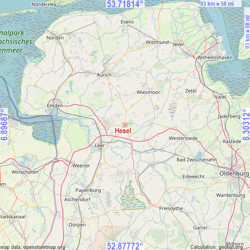
Hesel GPS coordinates[2]
53° 18' 0" North, 7° 36' 0" East
| Map corner | latitude | longitude |
|---|---|---|
| Upper-left | 53.71814°, | 6.89687° |
| Center: | 53.3°, | 7.6° |
| Lower-right: | 52.87772°, | 8.30312° |
| Map W x H: | 93.4×93.4 km | = 58×58mi |
| max Lat: | 55.01917° ⇑16.3% North |
| Hesel: | 53.3° |
| min Lat: | ⇓83.7% South 47.40724° |
| min Long | Hesel | max Long |
| 5.92978° | 7.6° | 14.98853° |
| W 14.9%⇐ | ⇒85.1% E |
Elevation
Elevation of Hesel is 11 m = 36 ft, and this is 238.1 m = 781 ft below average elevation for this country.
| Max E: |
1256 m = 4121 ft | 93.9% |
| Avg. | 249.1 m = 817 ft | |
| Hesel | 11 m = 36 ft | |
Min E: |
-5 m = -16 ft | 6.1% |
See also: Germany elevation on elevation.city.
Geographical zone
Hesel is located in North temperate zone (between Tropic of Cancer and the Arctic Circle). Distance of this North polar circle is 1474.8 km =916.4 mi to North.| Distance of | km | miles | from Hesel |
|---|---|---|---|
| North Pole | 4080.7 | 2535.6 | to North |
| Arctic Circle | 1474.8 | 916.4 | to North |
| Tropic Cancer | 3320.5 | 2063.3 | to South |
| Equator | 5926.4 | 3682.5 | to South |


Nearby cities:
15 places around Hesel: (largest is in red/bold)
• Apen
16.2 km =10.1 mi,  124°
124°
• Barßel
17.6 km =10.9 mi,  145°
145°
• Brinkum
4.3 km =2.7 mi,  210°
210°
• Detern
11.2 km =7 mi, 154°
• Filsum
6.7 km =4.2 mi,  163°
163°
• Firrel
5.8 km =3.6 mi,  50°
50°
• Holtland
2.2 km =1.4 mi, 210°
• Jemgum
14.9 km =9.3 mi,  255°
255°
• Leer
12 km =7.5 mi,  230°
230°
• Mittegroßefehn
10.4 km =6.5 mi,  347°
347°
• Neukamperfehn
4.8 km =3 mi,  327°
327°
• Nortmoor
6.3 km =3.9 mi,  197°
197°
• Ostrhauderfehn
18.6 km =11.6 mi,  176°
176°
• Schwerinsdorf
4.2 km =2.6 mi,  73°
73°
• Wiesmoor
15.7 km =9.8 mi,  34°
34°
Sources, notices
• [Note1] Compared only with cities in Germany existing in our database
• [Src1] Map data: © OpenStreetMap contributors (CC-BY-SA)
• [Src2] Other city data from geonames.org with taken over terms of usage.
• [Src3] Geographical zone / Annual Mean Temperature by Robert A. Rohde @ Wikipedia
